You are here: Home > Network List > US - United States National Seismic Network Stations List
> Station AMTX Amarillo, Texas, USA > Earthquake Result Viewer
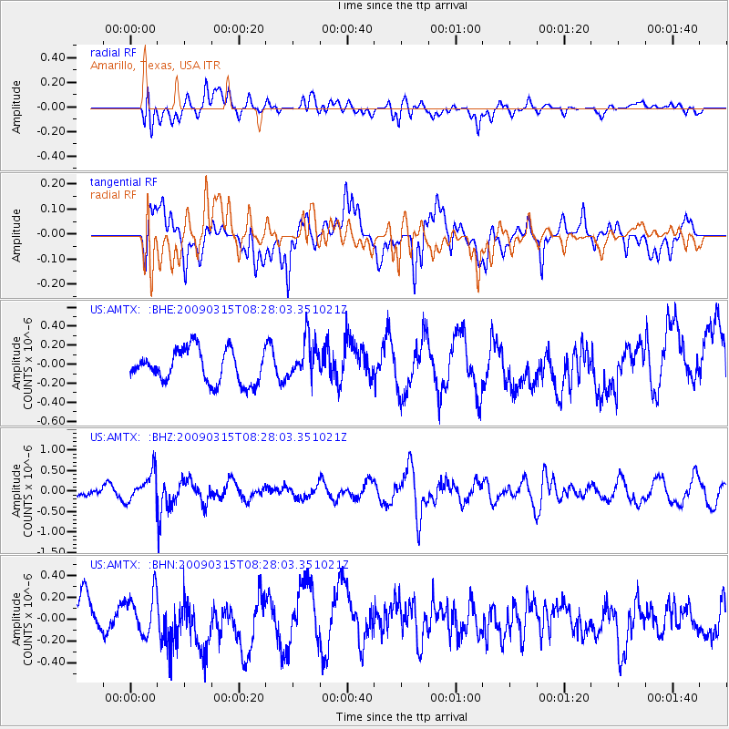
AMTX Amarillo, Texas, USA - Earthquake Result Viewer
*The percent match for this event was below the threshold and hence no stack was calculated.
| Earthquake location: |
Central Peru |
| Earthquake latitude/longitude: |
-14.5/-70.4 |
| Earthquake time(UTC): |
2009/03/15 (074) 08:19:05 GMT |
| Earthquake Depth: |
190 km |
| Earthquake Magnitude: |
5.7 MW, 5.1 MB, 5.6 MW |
| Earthquake Catalog/Contributor: |
WHDF/NEIC |
|
| Network: |
US United States National Seismic Network |
| Station: |
AMTX Amarillo, Texas, USA |
| Lat/Lon: |
34.53 N/101.41 W |
| Elevation: |
1010 m |
|
| Distance: |
57.0 deg |
| Az: |
329.475 deg |
| Baz: |
143.417 deg |
| Ray Param: |
$rayparam |
*The percent match for this event was below the threshold and hence was not used in the summary stack. |
|
| Radial Match: |
47.701878 % |
| Radial Bump: |
400 |
| Transverse Match: |
60.01786 % |
| Transverse Bump: |
400 |
| SOD ConfigId: |
2658 |
| Insert Time: |
2010-03-05 03:06:02.968 +0000 |
| GWidth: |
2.5 |
| Max Bumps: |
400 |
| Tol: |
0.001 |
|
Signal To Noise
| Channel | StoN | STA | LTA |
| US:AMTX: :BHZ:20090315T08:28:03.351021Z | 1.3482997 | 3.5838536E-7 | 2.658054E-7 |
| US:AMTX: :BHN:20090315T08:28:03.351021Z | 0.935793 | 1.807032E-7 | 1.9310168E-7 |
| US:AMTX: :BHE:20090315T08:28:03.351021Z | 0.71346456 | 1.2108026E-7 | 1.6970748E-7 |
| Arrivals |
| Ps | |
| PpPs | |
| PsPs/PpSs | |


