You are here: Home > Network List > US - United States National Seismic Network Stations List
> Station AMTX Amarillo, Texas, USA > Earthquake Result Viewer
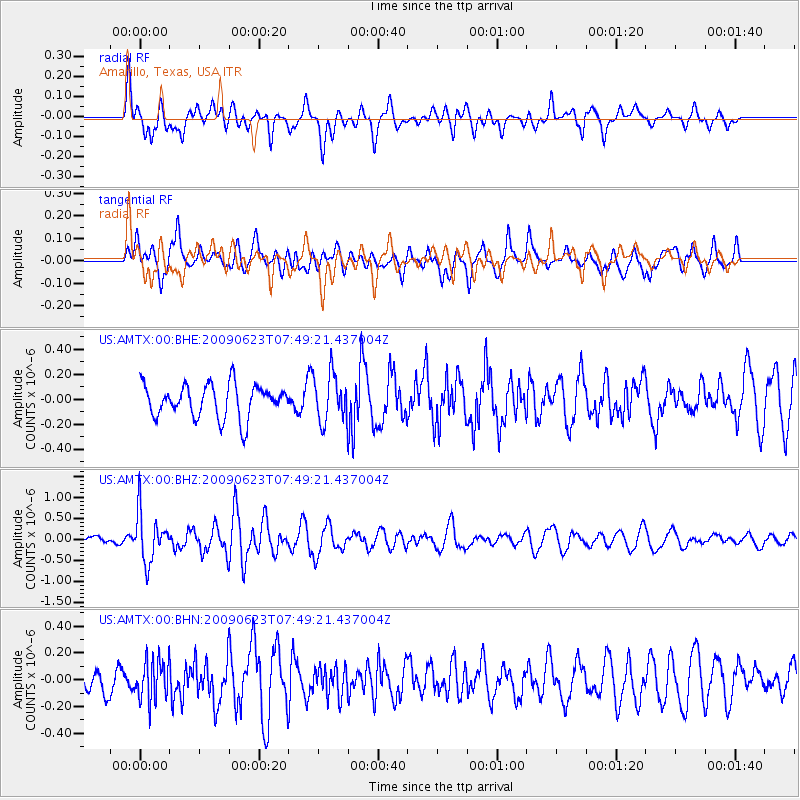
AMTX Amarillo, Texas, USA - Earthquake Result Viewer
*The percent match for this event was below the threshold and hence no stack was calculated.
| Earthquake location: |
Near East Coast Of Honshu, Japan |
| Earthquake latitude/longitude: |
38.8/142.4 |
| Earthquake time(UTC): |
2009/06/23 (174) 07:37:17 GMT |
| Earthquake Depth: |
37 km |
| Earthquake Magnitude: |
5.7 MB, 5.0 MS, 5.6 MW, 5.6 MW |
| Earthquake Catalog/Contributor: |
WHDF/NEIC |
|
| Network: |
US United States National Seismic Network |
| Station: |
AMTX Amarillo, Texas, USA |
| Lat/Lon: |
34.53 N/101.41 W |
| Elevation: |
1010 m |
|
| Distance: |
86.1 deg |
| Az: |
47.942 deg |
| Baz: |
315.394 deg |
| Ray Param: |
$rayparam |
*The percent match for this event was below the threshold and hence was not used in the summary stack. |
|
| Radial Match: |
57.987995 % |
| Radial Bump: |
400 |
| Transverse Match: |
54.79069 % |
| Transverse Bump: |
400 |
| SOD ConfigId: |
2648 |
| Insert Time: |
2010-03-05 03:06:05.491 +0000 |
| GWidth: |
2.5 |
| Max Bumps: |
400 |
| Tol: |
0.001 |
|
Signal To Noise
| Channel | StoN | STA | LTA |
| US:AMTX:00:BHZ:20090623T07:49:21.437004Z | 5.172664 | 5.7937075E-7 | 1.12006255E-7 |
| US:AMTX:00:BHN:20090623T07:49:21.437004Z | 1.1710185 | 1.5056297E-7 | 1.2857437E-7 |
| US:AMTX:00:BHE:20090623T07:49:21.437004Z | 1.6551473 | 2.1140833E-7 | 1.2772782E-7 |
| Arrivals |
| Ps | |
| PpPs | |
| PsPs/PpSs | |


