You are here: Home > Network List > US - United States National Seismic Network Stations List
> Station AMTX Amarillo, Texas, USA > Earthquake Result Viewer
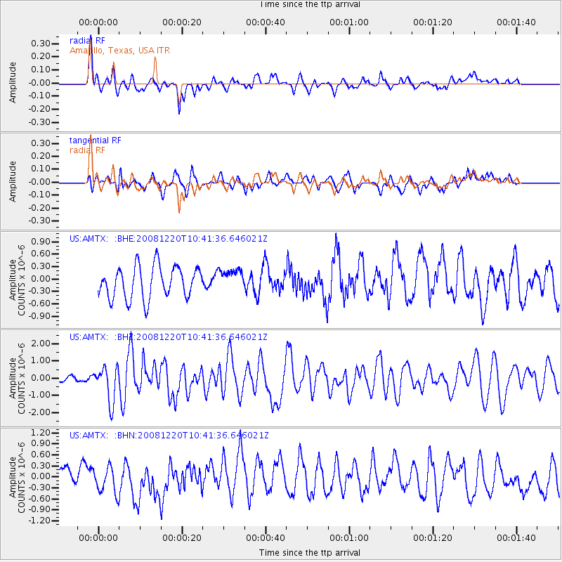
AMTX Amarillo, Texas, USA - Earthquake Result Viewer
*The percent match for this event was below the threshold and hence no stack was calculated.
| Earthquake location: |
Off East Coast Of Honshu, Japan |
| Earthquake latitude/longitude: |
36.5/142.4 |
| Earthquake time(UTC): |
2008/12/20 (355) 10:29:23 GMT |
| Earthquake Depth: |
19 km |
| Earthquake Magnitude: |
6.0 MB, 6.3 MS, 6.3 MW, 6.3 MW |
| Earthquake Catalog/Contributor: |
WHDF/NEIC |
|
| Network: |
US United States National Seismic Network |
| Station: |
AMTX Amarillo, Texas, USA |
| Lat/Lon: |
34.53 N/101.41 W |
| Elevation: |
1010 m |
|
| Distance: |
87.6 deg |
| Az: |
47.87 deg |
| Baz: |
313.662 deg |
| Ray Param: |
$rayparam |
*The percent match for this event was below the threshold and hence was not used in the summary stack. |
|
| Radial Match: |
62.062653 % |
| Radial Bump: |
400 |
| Transverse Match: |
55.332287 % |
| Transverse Bump: |
400 |
| SOD ConfigId: |
2658 |
| Insert Time: |
2010-03-05 03:06:06.259 +0000 |
| GWidth: |
2.5 |
| Max Bumps: |
400 |
| Tol: |
0.001 |
|
Signal To Noise
| Channel | StoN | STA | LTA |
| US:AMTX: :BHZ:20081220T10:41:36.646021Z | 3.8469222 | 1.0428511E-6 | 2.7108715E-7 |
| US:AMTX: :BHN:20081220T10:41:36.646021Z | 1.7358088 | 4.0627654E-7 | 2.3405603E-7 |
| US:AMTX: :BHE:20081220T10:41:36.646021Z | 0.61308086 | 2.3594738E-7 | 3.8485527E-7 |
| Arrivals |
| Ps | |
| PpPs | |
| PsPs/PpSs | |


