You are here: Home > Network List > US - United States National Seismic Network Stations List
> Station AMTX Amarillo, Texas, USA > Earthquake Result Viewer
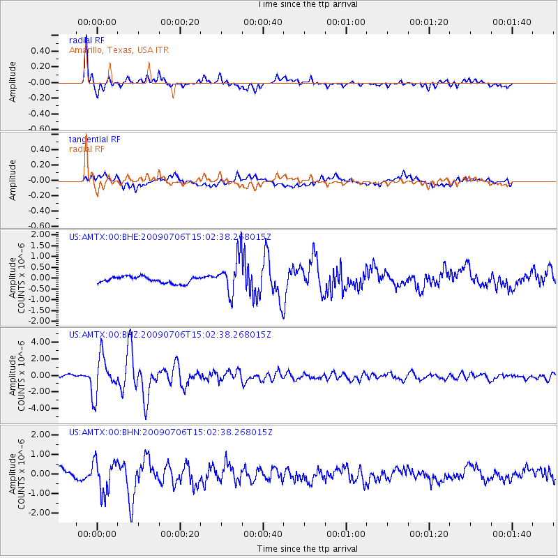
AMTX Amarillo, Texas, USA - Earthquake Result Viewer
*The percent match for this event was below the threshold and hence no stack was calculated.
| Earthquake location: |
Rat Islands, Aleutian Islands |
| Earthquake latitude/longitude: |
50.4/177.0 |
| Earthquake time(UTC): |
2009/07/06 (187) 14:53:12 GMT |
| Earthquake Depth: |
22 km |
| Earthquake Magnitude: |
6.0 MB, 5.8 MS, 6.1 MW, 6.0 MW |
| Earthquake Catalog/Contributor: |
WHDF/NEIC |
|
| Network: |
US United States National Seismic Network |
| Station: |
AMTX Amarillo, Texas, USA |
| Lat/Lon: |
34.53 N/101.41 W |
| Elevation: |
1010 m |
|
| Distance: |
59.3 deg |
| Az: |
71.827 deg |
| Baz: |
312.613 deg |
| Ray Param: |
$rayparam |
*The percent match for this event was below the threshold and hence was not used in the summary stack. |
|
| Radial Match: |
92.41647 % |
| Radial Bump: |
400 |
| Transverse Match: |
82.18185 % |
| Transverse Bump: |
400 |
| SOD ConfigId: |
2648 |
| Insert Time: |
2010-03-05 03:06:11.306 +0000 |
| GWidth: |
2.5 |
| Max Bumps: |
400 |
| Tol: |
0.001 |
|
Signal To Noise
| Channel | StoN | STA | LTA |
| US:AMTX:00:BHZ:20090706T15:02:38.268015Z | 15.309334 | 2.3284092E-6 | 1.5209083E-7 |
| US:AMTX:00:BHN:20090706T15:02:38.268015Z | 3.8690627 | 8.424459E-7 | 2.1773903E-7 |
| US:AMTX:00:BHE:20090706T15:02:38.268015Z | 6.7239876 | 1.0269382E-6 | 1.5272755E-7 |
| Arrivals |
| Ps | |
| PpPs | |
| PsPs/PpSs | |


