You are here: Home > Network List > TA - USArray Transportable Network (new EarthScope stations) Stations List
> Station L20K Farewell, AK, USA > Earthquake Result Viewer
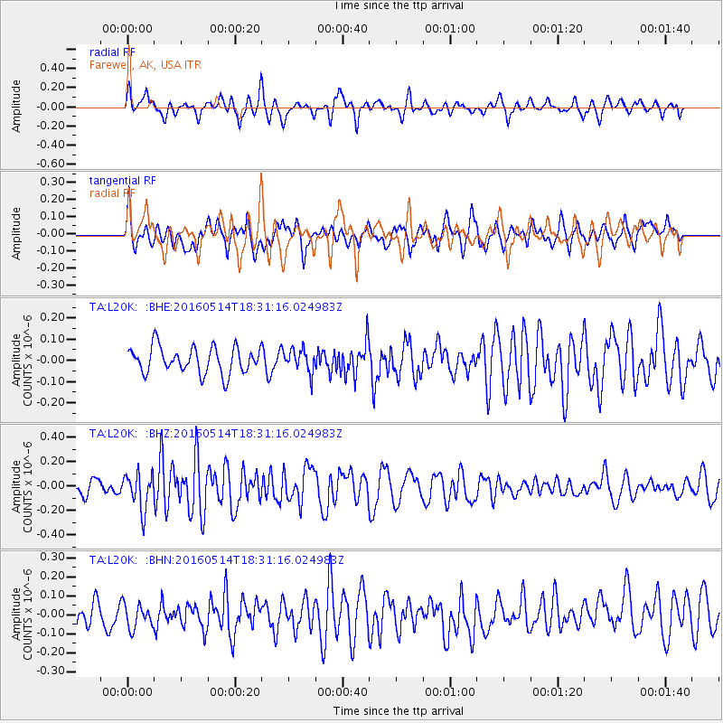
L20K Farewell, AK, USA - Earthquake Result Viewer
*The percent match for this event was below the threshold and hence no stack was calculated.
| Earthquake location: |
Northern East Pacific Rise |
| Earthquake latitude/longitude: |
8.5/-102.8 |
| Earthquake time(UTC): |
2016/05/14 (135) 18:21:05 GMT |
| Earthquake Depth: |
10 km |
| Earthquake Magnitude: |
5.8 MWW, 5.6 MWB, 5.7 MWC |
| Earthquake Catalog/Contributor: |
NEIC PDE/NEIC COMCAT |
|
| Network: |
TA USArray Transportable Network (new EarthScope stations) |
| Station: |
L20K Farewell, AK, USA |
| Lat/Lon: |
62.48 N/153.88 W |
| Elevation: |
673 m |
|
| Distance: |
65.2 deg |
| Az: |
336.554 deg |
| Baz: |
122.092 deg |
| Ray Param: |
$rayparam |
*The percent match for this event was below the threshold and hence was not used in the summary stack. |
|
| Radial Match: |
72.94075 % |
| Radial Bump: |
400 |
| Transverse Match: |
64.17507 % |
| Transverse Bump: |
400 |
| SOD ConfigId: |
7422571 |
| Insert Time: |
2019-04-22 14:11:44.932 +0000 |
| GWidth: |
2.5 |
| Max Bumps: |
400 |
| Tol: |
0.001 |
|
Signal To Noise
| Channel | StoN | STA | LTA |
| TA:L20K: :BHZ:20160514T18:31:16.024983Z | 2.8584194 | 1.4709717E-7 | 5.1461015E-8 |
| TA:L20K: :BHN:20160514T18:31:16.024983Z | 0.8560236 | 6.5342206E-8 | 7.633225E-8 |
| TA:L20K: :BHE:20160514T18:31:16.024983Z | 0.8906156 | 5.4817235E-8 | 6.154983E-8 |
| Arrivals |
| Ps | |
| PpPs | |
| PsPs/PpSs | |


