You are here: Home > Network List > TA - USArray Transportable Network (new EarthScope stations) Stations List
> Station N25K Chitina, Valdez-Cordova, AK, USA > Earthquake Result Viewer
N25K Chitina, Valdez-Cordova, AK, USA - Earthquake Result Viewer
| Earthquake location: |
Northern East Pacific Rise |
| Earthquake latitude/longitude: |
8.5/-102.8 |
| Earthquake time(UTC): |
2016/05/14 (135) 18:21:05 GMT |
| Earthquake Depth: |
10 km |
| Earthquake Magnitude: |
5.8 MWW, 5.6 MWB, 5.7 MWC |
| Earthquake Catalog/Contributor: |
NEIC PDE/NEIC COMCAT |
|
| Network: |
TA USArray Transportable Network (new EarthScope stations) |
| Station: |
N25K Chitina, Valdez-Cordova, AK, USA |
| Lat/Lon: |
61.61 N/144.60 W |
| Elevation: |
1087 m |
|
| Distance: |
61.2 deg |
| Az: |
338.693 deg |
| Baz: |
131.248 deg |
| Ray Param: |
0.061042674 |
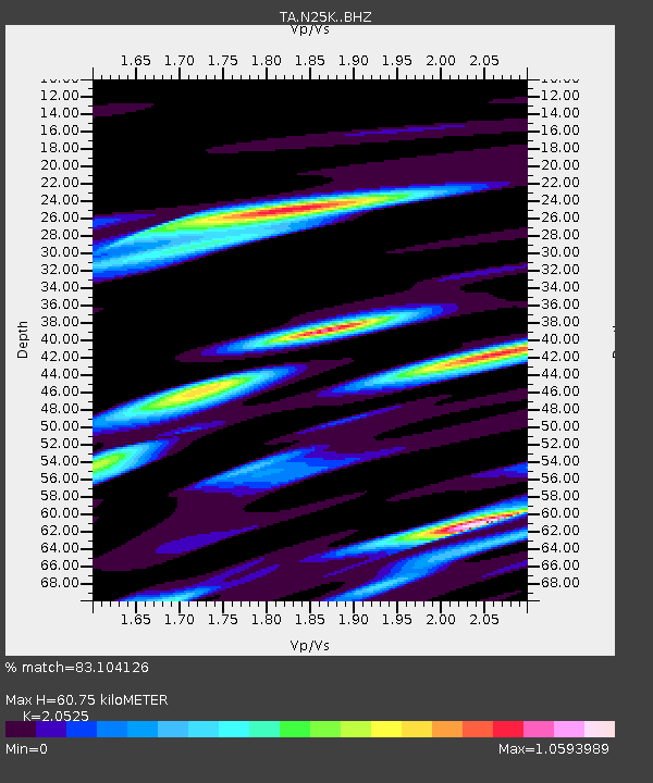
| Estimated Moho Depth: |
60.75 km |
| Estimated Crust Vp/Vs: |
2.05 |
| Assumed Crust Vp: |
6.566 km/s |
| Estimated Crust Vs: |
3.199 km/s |
| Estimated Crust Poisson's Ratio: |
0.34 |
|
| Radial Match: |
83.104126 % |
| Radial Bump: |
400 |
| Transverse Match: |
69.309616 % |
| Transverse Bump: |
400 |
| SOD ConfigId: |
7422571 |
| Insert Time: |
2019-04-22 14:11:54.044 +0000 |
| GWidth: |
2.5 |
| Max Bumps: |
400 |
| Tol: |
0.001 |
|

Signal To Noise
| Channel | StoN | STA | LTA |
| TA:N25K: :BHZ:20160514T18:30:49.349995Z | 2.5095437 | 1.5804304E-7 | 6.29768E-8 |
| TA:N25K: :BHN:20160514T18:30:49.349995Z | 1.7177609 | 8.5787164E-8 | 4.994127E-8 |
| TA:N25K: :BHE:20160514T18:30:49.349995Z | 0.92237145 | 6.053781E-8 | 6.563278E-8 |
| Arrivals |
| Ps | 10 SECOND |
| PpPs | 27 SECOND |
| PsPs/PpSs | 37 SECOND |


