You are here: Home > Network List > US - United States National Seismic Network Stations List
> Station ACSO Alum Creek State Park, Ohio, USA > Earthquake Result Viewer
ACSO Alum Creek State Park, Ohio, USA - Earthquake Result Viewer

| Earthquake location: |
Turkmenistan |
| Earthquake latitude/longitude: |
39.6/54.8 |
| Earthquake time(UTC): |
2000/12/06 (341) 17:11:06 GMT |
| Earthquake Depth: |
30 km |
| Earthquake Magnitude: |
6.7 MB, 7.5 MS, 7.0 MW, 6.9 ME |
| Earthquake Catalog/Contributor: |
WHDF/NEIC |
|
| Network: |
US United States National Seismic Network |
| Station: |
ACSO Alum Creek State Park, Ohio, USA |
| Lat/Lon: |
40.23 N/82.98 W |
| Elevation: |
288 m |
|
| Distance: |
91.7 deg |
| Az: |
329.025 deg |
| Baz: |
31.309 deg |
| Ray Param: |
0.041558996 |
| Estimated Moho Depth: |
20.5 km |
| Estimated Crust Vp/Vs: |
2.07 |
| Assumed Crust Vp: |
6.498 km/s |
| Estimated Crust Vs: |
3.143 km/s |
| Estimated Crust Poisson's Ratio: |
0.35 |
|
| Radial Match: |
91.982956 % |
| Radial Bump: |
400 |
| Transverse Match: |
75.02083 % |
| Transverse Bump: |
400 |
| SOD ConfigId: |
20082 |
| Insert Time: |
2010-03-05 03:06:21.907 +0000 |
| GWidth: |
2.5 |
| Max Bumps: |
400 |
| Tol: |
0.001 |
|
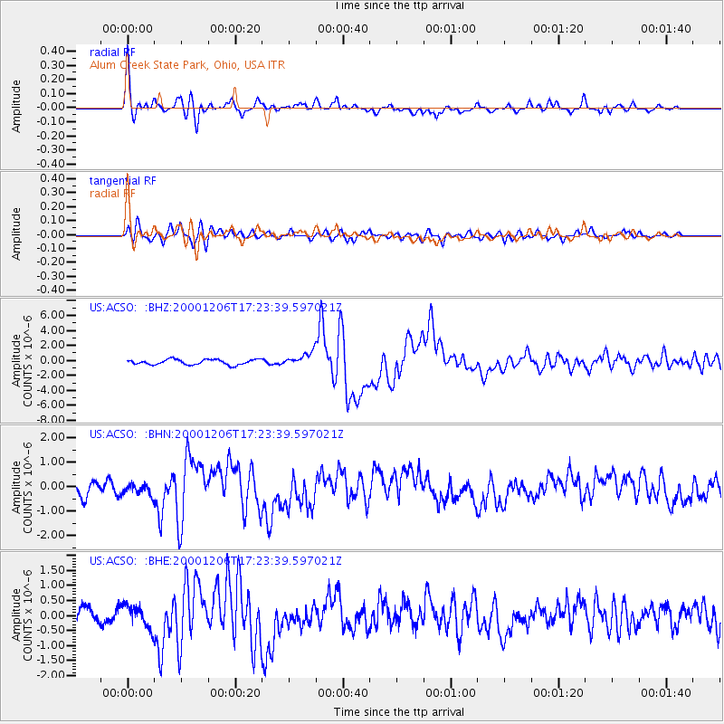
Signal To Noise
| Channel | StoN | STA | LTA |
| US:ACSO: :BHN:20001206T17:23:39.597021Z | 1.0527517 | 2.3189993E-7 | 2.2027979E-7 |
| US:ACSO: :BHE:20001206T17:23:39.597021Z | 1.1929547 | 3.7528756E-7 | 3.145866E-7 |
| US:ACSO: :BHZ:20001206T17:23:39.597021Z | 2.7343688 | 9.4462075E-7 | 3.454621E-7 |
| Arrivals |
| Ps | 3.4 SECOND |
| PpPs | 9.5 SECOND |
| PsPs/PpSs | 13 SECOND |


