You are here: Home > Network List > US - United States National Seismic Network Stations List
> Station ACSO Alum Creek State Park, Ohio, USA > Earthquake Result Viewer
ACSO Alum Creek State Park, Ohio, USA - Earthquake Result Viewer
| Earthquake location: |
Panama-Colombia Border Region |
| Earthquake latitude/longitude: |
7.0/-77.8 |
| Earthquake time(UTC): |
2000/11/08 (313) 06:59:58 GMT |
| Earthquake Depth: |
17 km |
| Earthquake Magnitude: |
6.0 MB, 6.4 MS, 6.5 MW, 6.2 ML |
| Earthquake Catalog/Contributor: |
WHDF/NEIC |
|
| Network: |
US United States National Seismic Network |
| Station: |
ACSO Alum Creek State Park, Ohio, USA |
| Lat/Lon: |
40.23 N/82.98 W |
| Elevation: |
288 m |
|
| Distance: |
33.4 deg |
| Az: |
352.818 deg |
| Baz: |
170.672 deg |
| Ray Param: |
0.07822486 |
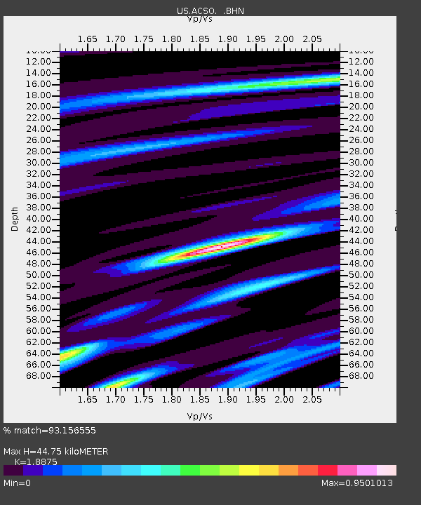
| Estimated Moho Depth: |
44.75 km |
| Estimated Crust Vp/Vs: |
1.89 |
| Assumed Crust Vp: |
6.498 km/s |
| Estimated Crust Vs: |
3.442 km/s |
| Estimated Crust Poisson's Ratio: |
0.30 |
|
| Radial Match: |
93.156555 % |
| Radial Bump: |
312 |
| Transverse Match: |
73.05312 % |
| Transverse Bump: |
400 |
| SOD ConfigId: |
110165 |
| Insert Time: |
2010-03-05 03:06:24.412 +0000 |
| GWidth: |
2.5 |
| Max Bumps: |
400 |
| Tol: |
0.001 |
|
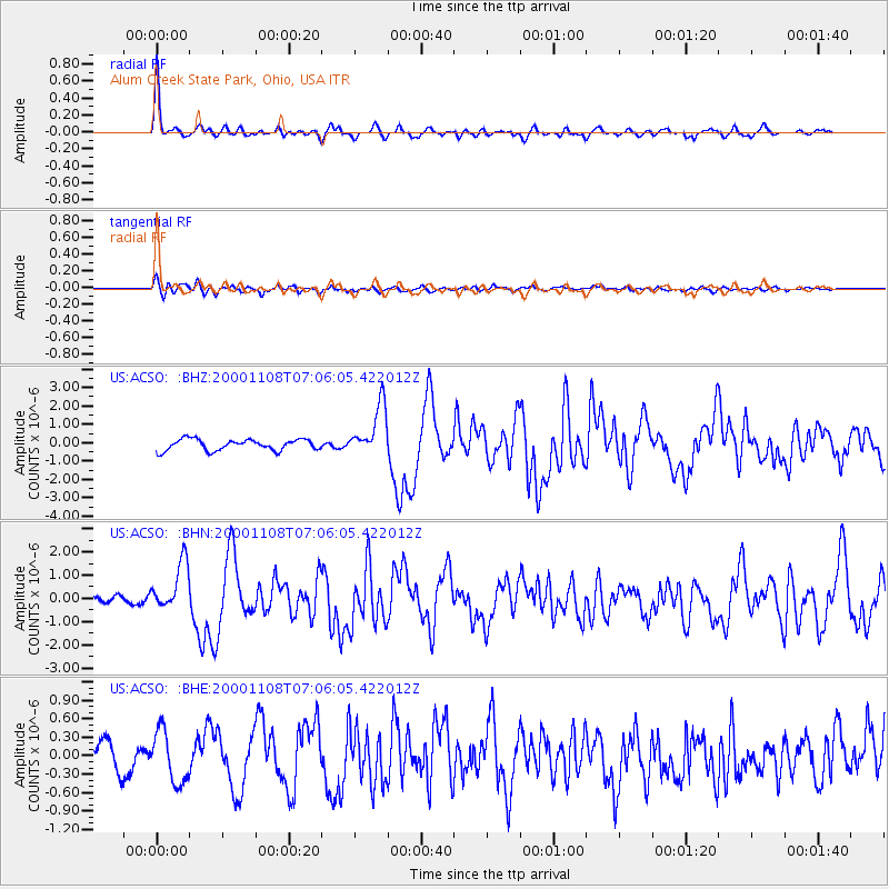
Signal To Noise
| Channel | StoN | STA | LTA |
| US:ACSO: :BHN:20001108T07:06:05.422012Z | 5.009141 | 1.0599456E-6 | 2.1160227E-7 |
| US:ACSO: :BHE:20001108T07:06:05.422012Z | 2.3674173 | 4.1627322E-7 | 1.7583432E-7 |
| US:ACSO: :BHZ:20001108T07:06:05.422012Z | 4.6085763 | 1.3836477E-6 | 3.002332E-7 |
| Arrivals |
| Ps | 6.6 SECOND |
| PpPs | 18 SECOND |
| PsPs/PpSs | 25 SECOND |


