You are here: Home > Network List > US - United States National Seismic Network Stations List
> Station ACSO Alum Creek State Park, Ohio, USA > Earthquake Result Viewer
ACSO Alum Creek State Park, Ohio, USA - Earthquake Result Viewer

| Earthquake location: |
South Of Panama |
| Earthquake latitude/longitude: |
7.6/-82.8 |
| Earthquake time(UTC): |
2001/08/25 (237) 02:02:02 GMT |
| Earthquake Depth: |
24 km |
| Earthquake Magnitude: |
5.9 MB, 5.7 MS, 6.2 MW, 6.1 MW |
| Earthquake Catalog/Contributor: |
WHDF/NEIC |
|
| Network: |
US United States National Seismic Network |
| Station: |
ACSO Alum Creek State Park, Ohio, USA |
| Lat/Lon: |
40.23 N/82.98 W |
| Elevation: |
288 m |
|
| Distance: |
32.5 deg |
| Az: |
359.692 deg |
| Baz: |
179.601 deg |
| Ray Param: |
0.07861224 |
| Estimated Moho Depth: |
47.5 km |
| Estimated Crust Vp/Vs: |
1.78 |
| Assumed Crust Vp: |
6.498 km/s |
| Estimated Crust Vs: |
3.645 km/s |
| Estimated Crust Poisson's Ratio: |
0.27 |
|
| Radial Match: |
92.969475 % |
| Radial Bump: |
320 |
| Transverse Match: |
83.771576 % |
| Transverse Bump: |
400 |
| SOD ConfigId: |
110165 |
| Insert Time: |
2010-03-05 03:06:41.023 +0000 |
| GWidth: |
2.5 |
| Max Bumps: |
400 |
| Tol: |
0.001 |
|
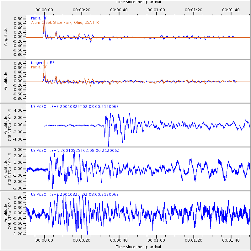
Signal To Noise
| Channel | StoN | STA | LTA |
| US:ACSO: :BHN:20010825T02:08:00.212006Z | 10.09204 | 1.1971962E-6 | 1.1862776E-7 |
| US:ACSO: :BHE:20010825T02:08:00.212006Z | 2.1596613 | 3.2023914E-7 | 1.4828211E-7 |
| US:ACSO: :BHZ:20010825T02:08:00.212006Z | 20.867043 | 1.9953723E-6 | 9.562315E-8 |
| Arrivals |
| Ps | 6.2 SECOND |
| PpPs | 19 SECOND |
| PsPs/PpSs | 25 SECOND |


