You are here: Home > Network List > KN - Kyrgyz Seismic Telemetry Network Stations List
> Station TKM2 - > Earthquake Result Viewer
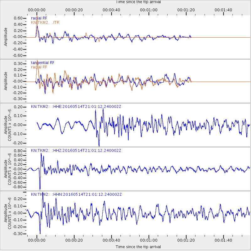
TKM2 - - Earthquake Result Viewer
*The percent match for this event was below the threshold and hence no stack was calculated.
| Earthquake location: |
Southwest Of Sumatra, Indonesia |
| Earthquake latitude/longitude: |
-6.9/101.8 |
| Earthquake time(UTC): |
2016/05/14 (135) 20:52:11 GMT |
| Earthquake Depth: |
10 km |
| Earthquake Magnitude: |
5.6 MB, 5.3 MWW |
| Earthquake Catalog/Contributor: |
NEIC PDE/NEIC COMCAT |
|
| Network: |
KN Kyrgyz Seismic Telemetry Network |
| Station: |
TKM2 - |
| Lat/Lon: |
42.92 N/75.60 E |
| Elevation: |
2020 m |
|
| Distance: |
55.0 deg |
| Az: |
336.679 deg |
| Baz: |
147.648 deg |
| Ray Param: |
$rayparam |
*The percent match for this event was below the threshold and hence was not used in the summary stack. |
|
| Radial Match: |
79.09394 % |
| Radial Bump: |
400 |
| Transverse Match: |
55.867958 % |
| Transverse Bump: |
400 |
| SOD ConfigId: |
7422571 |
| Insert Time: |
2019-04-22 14:15:59.475 +0000 |
| GWidth: |
2.5 |
| Max Bumps: |
400 |
| Tol: |
0.001 |
|
Signal To Noise
| Channel | StoN | STA | LTA |
| KN:TKM2: :HHZ:20160514T21:01:12.240002Z | 8.408689 | 3.339822E-7 | 3.9718707E-8 |
| KN:TKM2: :HHN:20160514T21:01:12.240002Z | 4.6740956 | 1.218528E-7 | 2.6069815E-8 |
| KN:TKM2: :HHE:20160514T21:01:12.240002Z | 2.5661185 | 9.011584E-8 | 3.511757E-8 |
| Arrivals |
| Ps | |
| PpPs | |
| PsPs/PpSs | |


