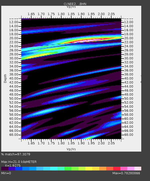
NEE2 Needles Airport - Earthquake Result Viewer
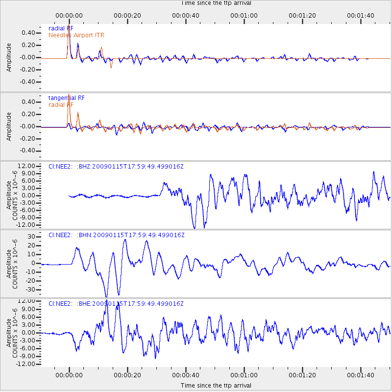
Earthquake location: East Of Kuril Islands
Earthquake latitude/longitude: 46.9/155.2
Earthquake time(UTC): 2009/01/15 (015) 17:49:39 GMT
Earthquake Depth: 36 km
Earthquake Magnitude: 6.9 MB, 7.5 MS, 7.4 MW, 7.4 MW
Earthquake Catalog/Contributor: WHDF/NEIC
Network: CI Caltech Regional Seismic Network
Station: NEE2 Needles Airport
Lat/Lon: 34.77 N/114.62 W
Elevation: 271 m
Distance: 65.8 deg
Az: 64.541 deg
Baz: 311.18 deg
Ray Param: 0.05800345
Estimated Moho Depth: 21.0 km
Estimated Crust Vp/Vs: 1.93
Assumed Crust Vp: 6.276 km/s
Estimated Crust Vs: 3.256 km/s
Estimated Crust Poisson's Ratio: 0.32
Radial Match: 97.3079 %
Radial Bump: 349
Transverse Match: 88.181526 %
Transverse Bump: 400
SOD ConfigId: 2834
Insert Time: 2010-02-26 00:21:57.658 +0000
GWidth: 2.5
Max Bumps: 400
Tol: 0.001

Signal To Noise

ChannelStoNSTALTA
CI:NEE2: :BHN:20090115T17:59:49.499016Z35.751211.0073785E-52.8177467E-7
CI:NEE2: :BHE:20090115T17:59:49.499016Z17.7922673.2227597E-61.8113262E-7
CI:NEE2: :BHZ:20090115T17:59:49.499016Z8.7813542.9522541E-63.3619577E-7
Arrivals
Ps3.2 SECOND
PpPs9.5 SECOND
PsPs/PpSs13 SECOND