You are here: Home > Network List > XL12 - Hangay Dome, Mongolia Stations List
> Station HV15 HV15 > Earthquake Result Viewer
HV15 HV15 - Earthquake Result Viewer
| Earthquake location: |
Southwest Of Sumatra, Indonesia |
| Earthquake latitude/longitude: |
-6.9/101.8 |
| Earthquake time(UTC): |
2016/05/14 (135) 20:52:11 GMT |
| Earthquake Depth: |
10 km |
| Earthquake Magnitude: |
5.6 MB, 5.3 MWW |
| Earthquake Catalog/Contributor: |
NEIC PDE/NEIC COMCAT |
|
| Network: |
XL Hangay Dome, Mongolia |
| Station: |
HV15 HV15 |
| Lat/Lon: |
50.11 N/100.06 E |
| Elevation: |
1569 m |
|
| Distance: |
56.8 deg |
| Az: |
358.671 deg |
| Baz: |
177.95 deg |
| Ray Param: |
0.06392518 |
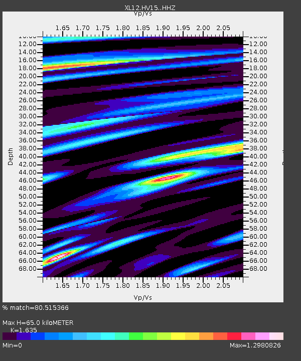
| Estimated Moho Depth: |
65.0 km |
| Estimated Crust Vp/Vs: |
1.63 |
| Assumed Crust Vp: |
6.419 km/s |
| Estimated Crust Vs: |
3.926 km/s |
| Estimated Crust Poisson's Ratio: |
0.20 |
|
| Radial Match: |
80.515366 % |
| Radial Bump: |
400 |
| Transverse Match: |
49.78872 % |
| Transverse Bump: |
400 |
| SOD ConfigId: |
7422571 |
| Insert Time: |
2019-04-22 14:17:24.817 +0000 |
| GWidth: |
2.5 |
| Max Bumps: |
400 |
| Tol: |
0.001 |
|

Signal To Noise
| Channel | StoN | STA | LTA |
| XL:HV15: :HHZ:20160514T21:01:25.008984Z | 5.0694995 | 1.9058622E-7 | 3.7594678E-8 |
| XL:HV15: :HHN:20160514T21:01:25.008984Z | 6.321478 | 1.035556E-7 | 1.6381549E-8 |
| XL:HV15: :HHE:20160514T21:01:25.008984Z | 2.0548706 | 3.0102463E-8 | 1.4649322E-8 |
| Arrivals |
| Ps | 6.8 SECOND |
| PpPs | 25 SECOND |
| PsPs/PpSs | 32 SECOND |


