You are here: Home > Network List > US - United States National Seismic Network Stations List
> Station ACSO Alum Creek State Park, Ohio, USA > Earthquake Result Viewer
ACSO Alum Creek State Park, Ohio, USA - Earthquake Result Viewer
| Earthquake location: |
Northwest Of Kuril Islands |
| Earthquake latitude/longitude: |
47.8/146.2 |
| Earthquake time(UTC): |
2002/11/17 (321) 04:53:53 GMT |
| Earthquake Depth: |
459 km |
| Earthquake Magnitude: |
7.3 MW, 7.3 MW |
| Earthquake Catalog/Contributor: |
WHDF/NEIC |
|
| Network: |
US United States National Seismic Network |
| Station: |
ACSO Alum Creek State Park, Ohio, USA |
| Lat/Lon: |
40.23 N/82.98 W |
| Elevation: |
288 m |
|
| Distance: |
82.1 deg |
| Az: |
35.808 deg |
| Baz: |
329.003 deg |
| Ray Param: |
0.04585713 |
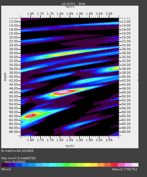
| Estimated Moho Depth: |
47.5 km |
| Estimated Crust Vp/Vs: |
1.81 |
| Assumed Crust Vp: |
6.498 km/s |
| Estimated Crust Vs: |
3.59 km/s |
| Estimated Crust Poisson's Ratio: |
0.28 |
|
| Radial Match: |
94.003685 % |
| Radial Bump: |
326 |
| Transverse Match: |
85.93149 % |
| Transverse Bump: |
386 |
| SOD ConfigId: |
4714 |
| Insert Time: |
2010-03-05 03:07:25.430 +0000 |
| GWidth: |
2.5 |
| Max Bumps: |
400 |
| Tol: |
0.001 |
|
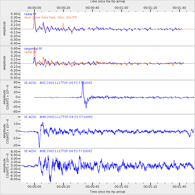
Signal To Noise
| Channel | StoN | STA | LTA |
| US:ACSO: :BHN:20021117T05:04:53.571006Z | 14.7943945 | 7.453066E-6 | 5.0377633E-7 |
| US:ACSO: :BHE:20021117T05:04:53.571006Z | 4.524024 | 1.8730725E-6 | 4.1402797E-7 |
| US:ACSO: :BHZ:20021117T05:04:53.571006Z | 36.440845 | 2.0635458E-5 | 5.662728E-7 |
| Arrivals |
| Ps | 6.1 SECOND |
| PpPs | 20 SECOND |
| PsPs/PpSs | 26 SECOND |


