You are here: Home > Network List > US - United States National Seismic Network Stations List
> Station ACSO Alum Creek State Park, Ohio, USA > Earthquake Result Viewer
ACSO Alum Creek State Park, Ohio, USA - Earthquake Result Viewer
| Earthquake location: |
Primor'ye, Russia |
| Earthquake latitude/longitude: |
47.2/139.2 |
| Earthquake time(UTC): |
2003/07/27 (208) 06:25:31 GMT |
| Earthquake Depth: |
470 km |
| Earthquake Magnitude: |
6.3 MB, 6.8 MW, 6.8 MW |
| Earthquake Catalog/Contributor: |
WHDF/NEIC |
|
| Network: |
US United States National Seismic Network |
| Station: |
ACSO Alum Creek State Park, Ohio, USA |
| Lat/Lon: |
40.23 N/82.98 W |
| Elevation: |
288 m |
|
| Distance: |
85.2 deg |
| Az: |
31.087 deg |
| Baz: |
332.592 deg |
| Ray Param: |
0.043630615 |
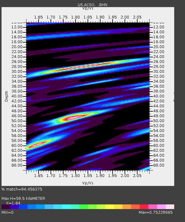
| Estimated Moho Depth: |
59.5 km |
| Estimated Crust Vp/Vs: |
1.64 |
| Assumed Crust Vp: |
6.498 km/s |
| Estimated Crust Vs: |
3.962 km/s |
| Estimated Crust Poisson's Ratio: |
0.20 |
|
| Radial Match: |
94.456375 % |
| Radial Bump: |
400 |
| Transverse Match: |
90.409935 % |
| Transverse Bump: |
400 |
| SOD ConfigId: |
110177 |
| Insert Time: |
2010-03-05 03:07:48.976 +0000 |
| GWidth: |
2.5 |
| Max Bumps: |
400 |
| Tol: |
0.001 |
|
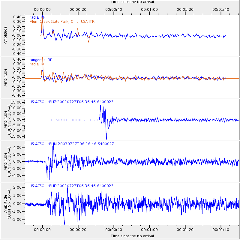
Signal To Noise
| Channel | StoN | STA | LTA |
| US:ACSO: :BHN:20030727T06:36:46.640002Z | 11.722908 | 1.4844576E-6 | 1.2662878E-7 |
| US:ACSO: :BHE:20030727T06:36:46.640002Z | 4.4623356 | 3.296828E-7 | 7.388122E-8 |
| US:ACSO: :BHZ:20030727T06:36:46.640002Z | 59.81927 | 4.4272415E-6 | 7.401029E-8 |
| Arrivals |
| Ps | 6.0 SECOND |
| PpPs | 24 SECOND |
| PsPs/PpSs | 30 SECOND |


