You are here: Home > Network List > US - United States National Seismic Network Stations List
> Station ACSO Alum Creek State Park, Ohio, USA > Earthquake Result Viewer
ACSO Alum Creek State Park, Ohio, USA - Earthquake Result Viewer
| Earthquake location: |
Kuril Islands |
| Earthquake latitude/longitude: |
47.2/151.3 |
| Earthquake time(UTC): |
2004/07/08 (190) 10:30:49 GMT |
| Earthquake Depth: |
128 km |
| Earthquake Magnitude: |
5.9 MB, 6.4 MW, 6.3 MW |
| Earthquake Catalog/Contributor: |
WHDF/NEIC |
|
| Network: |
US United States National Seismic Network |
| Station: |
ACSO Alum Creek State Park, Ohio, USA |
| Lat/Lon: |
40.23 N/82.98 W |
| Elevation: |
288 m |
|
| Distance: |
80.5 deg |
| Az: |
39.073 deg |
| Baz: |
325.844 deg |
| Ray Param: |
0.04797123 |
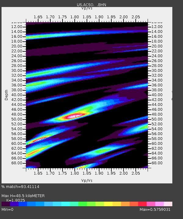
| Estimated Moho Depth: |
48.5 km |
| Estimated Crust Vp/Vs: |
1.80 |
| Assumed Crust Vp: |
6.498 km/s |
| Estimated Crust Vs: |
3.605 km/s |
| Estimated Crust Poisson's Ratio: |
0.28 |
|
| Radial Match: |
93.41114 % |
| Radial Bump: |
389 |
| Transverse Match: |
69.49781 % |
| Transverse Bump: |
400 |
| SOD ConfigId: |
110177 |
| Insert Time: |
2010-03-05 03:08:19.379 +0000 |
| GWidth: |
2.5 |
| Max Bumps: |
400 |
| Tol: |
0.001 |
|

Signal To Noise
| Channel | StoN | STA | LTA |
| US:ACSO: :BHN:20040708T10:42:15.646023Z | 2.5305765 | 3.5373495E-7 | 1.3978433E-7 |
| US:ACSO: :BHE:20040708T10:42:15.646023Z | 1.2904848 | 2.3643258E-7 | 1.8321221E-7 |
| US:ACSO: :BHZ:20040708T10:42:15.646023Z | 7.90637 | 9.468451E-7 | 1.1975725E-7 |
| Arrivals |
| Ps | 6.2 SECOND |
| PpPs | 20 SECOND |
| PsPs/PpSs | 27 SECOND |


