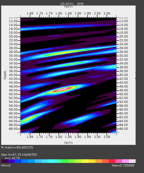
ACSO Alum Creek State Park, Ohio, USA - Earthquake Result Viewer
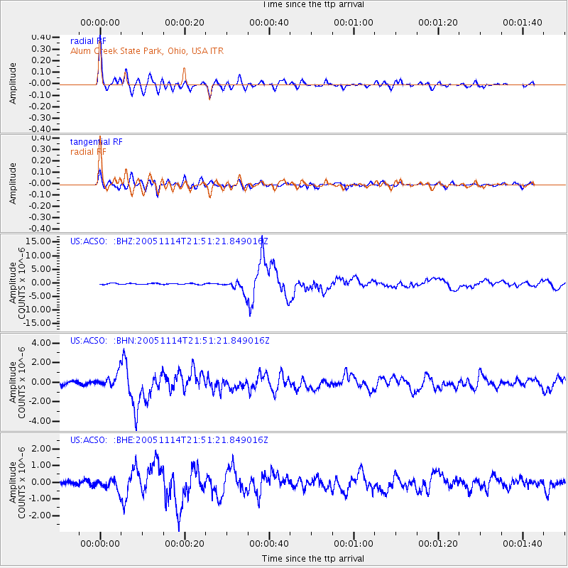
Earthquake location: Off East Coast Of Honshu, Japan
Earthquake latitude/longitude: 38.1/144.9
Earthquake time(UTC): 2005/11/14 (318) 21:38:51 GMT
Earthquake Depth: 11 km
Earthquake Magnitude: 6.7 MB, 6.8 MS, 7.0 MW, 6.9 MW
Earthquake Catalog/Contributor: WHDF/NEIC
Network: US United States National Seismic Network
Station: ACSO Alum Creek State Park, Ohio, USA
Lat/Lon: 40.23 N/82.98 W
Elevation: 288 m
Distance: 90.6 deg
Az: 34.601 deg
Baz: 324.187 deg
Ray Param: 0.04166488
Estimated Moho Depth: 47.25 km
Estimated Crust Vp/Vs: 1.82
Assumed Crust Vp: 6.498 km/s
Estimated Crust Vs: 3.575 km/s
Estimated Crust Poisson's Ratio: 0.28
Radial Match: 95.688225 %
Radial Bump: 400
Transverse Match: 93.02845 %
Transverse Bump: 400
SOD ConfigId: 2448
Insert Time: 2010-03-05 03:08:30.575 +0000
GWidth: 2.5
Max Bumps: 400
Tol: 0.001

Signal To Noise

ChannelStoNSTALTA
US:ACSO: :BHN:20051114T21:51:21.849016Z3.69346887.5347333E-72.0400154E-7
US:ACSO: :BHE:20051114T21:51:21.849016Z2.01073223.205196E-71.5940444E-7
US:ACSO: :BHZ:20051114T21:51:21.849016Z12.7299312.4995886E-61.9635526E-7
Arrivals
Ps6.1 SECOND
PpPs20 SECOND
PsPs/PpSs26 SECOND