You are here: Home > Network List > CI - Caltech Regional Seismic Network Stations List
> Station NEE2 Needles Airport > Earthquake Result Viewer
NEE2 Needles Airport - Earthquake Result Viewer
| Earthquake location: |
Mariana Islands |
| Earthquake latitude/longitude: |
18.9/145.4 |
| Earthquake time(UTC): |
2007/10/31 (304) 03:30:17 GMT |
| Earthquake Depth: |
223 km |
| Earthquake Magnitude: |
6.2 MB, 7.2 MW, 7.2 MW |
| Earthquake Catalog/Contributor: |
WHDF/NEIC |
|
| Network: |
CI Caltech Regional Seismic Network |
| Station: |
NEE2 Needles Airport |
| Lat/Lon: |
34.77 N/114.62 W |
| Elevation: |
271 m |
|
| Distance: |
87.3 deg |
| Az: |
54.254 deg |
| Baz: |
291.033 deg |
| Ray Param: |
0.042898286 |
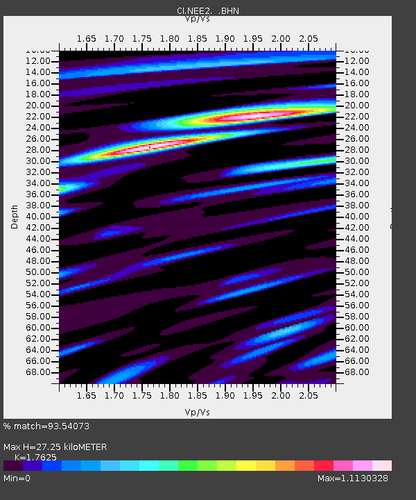
| Estimated Moho Depth: |
27.25 km |
| Estimated Crust Vp/Vs: |
1.76 |
| Assumed Crust Vp: |
6.276 km/s |
| Estimated Crust Vs: |
3.561 km/s |
| Estimated Crust Poisson's Ratio: |
0.26 |
|
| Radial Match: |
93.54073 % |
| Radial Bump: |
400 |
| Transverse Match: |
77.07504 % |
| Transverse Bump: |
400 |
| SOD ConfigId: |
2564 |
| Insert Time: |
2010-02-26 00:22:06.755 +0000 |
| GWidth: |
2.5 |
| Max Bumps: |
400 |
| Tol: |
0.001 |
|
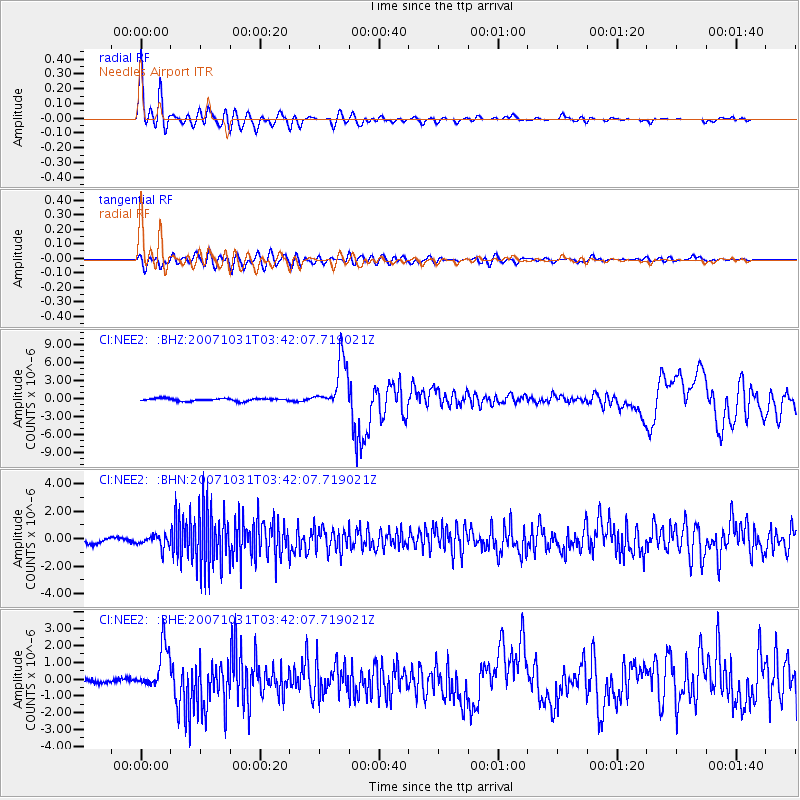
Signal To Noise
| Channel | StoN | STA | LTA |
| CI:NEE2: :BHN:20071031T03:42:07.719021Z | 2.2865658 | 4.326039E-7 | 1.8919373E-7 |
| CI:NEE2: :BHE:20071031T03:42:07.719021Z | 8.072654 | 1.2770291E-6 | 1.5819198E-7 |
| CI:NEE2: :BHZ:20071031T03:42:07.719021Z | 18.942118 | 4.143077E-6 | 2.1872302E-7 |
| Arrivals |
| Ps | 3.4 SECOND |
| PpPs | 12 SECOND |
| PsPs/PpSs | 15 SECOND |


