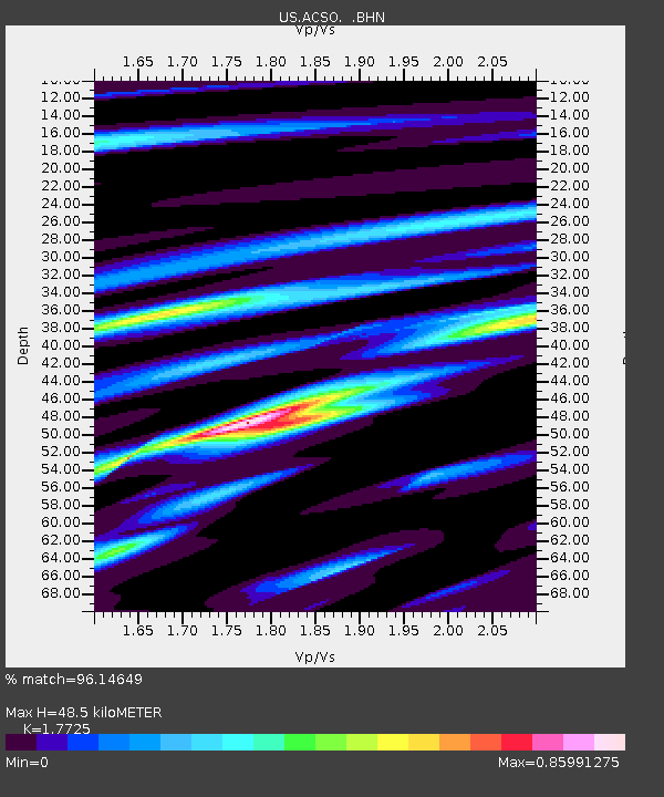
ACSO Alum Creek State Park, Ohio, USA - Earthquake Result Viewer

Earthquake location: Andreanof Islands, Aleutian Is.
Earthquake latitude/longitude: 51.9/-177.5
Earthquake time(UTC): 2008/05/02 (123) 01:33:37 GMT
Earthquake Depth: 14 km
Earthquake Magnitude: 6.3 MB, 6.8 MS, 6.6 MW, 6.6 MW
Earthquake Catalog/Contributor: WHDF/NEIC
Network: US United States National Seismic Network
Station: ACSO Alum Creek State Park, Ohio, USA
Lat/Lon: 40.23 N/82.98 W
Elevation: 288 m
Distance: 62.2 deg
Az: 59.667 deg
Baz: 315.645 deg
Ray Param: 0.060405504
Estimated Moho Depth: 48.5 km
Estimated Crust Vp/Vs: 1.77
Assumed Crust Vp: 6.498 km/s
Estimated Crust Vs: 3.666 km/s
Estimated Crust Poisson's Ratio: 0.27
Radial Match: 96.14649 %
Radial Bump: 326
Transverse Match: 81.61228 %
Transverse Bump: 400
SOD ConfigId: 2504
Insert Time: 2010-03-05 03:08:41.233 +0000
GWidth: 2.5
Max Bumps: 400
Tol: 0.001

Signal To Noise

ChannelStoNSTALTA
US:ACSO: :BHN:20080502T01:43:26.724009Z17.3681581.4938057E-68.60083E-8
US:ACSO: :BHE:20080502T01:43:26.724009Z4.20241456.600731E-71.5706996E-7
US:ACSO: :BHZ:20080502T01:43:26.724009Z4.6005353.9693901E-78.628106E-8
Arrivals
Ps6.0 SECOND
PpPs20 SECOND
PsPs/PpSs26 SECOND