You are here: Home > Network List > CI - Caltech Regional Seismic Network Stations List
> Station NEE2 Needles Airport > Earthquake Result Viewer
NEE2 Needles Airport - Earthquake Result Viewer
| Earthquake location: |
South Of Fiji Islands |
| Earthquake latitude/longitude: |
-25.8/179.5 |
| Earthquake time(UTC): |
2007/10/16 (289) 21:05:43 GMT |
| Earthquake Depth: |
509 km |
| Earthquake Magnitude: |
6.2 MB, 6.6 MW, 6.5 MW |
| Earthquake Catalog/Contributor: |
WHDF/NEIC |
|
| Network: |
CI Caltech Regional Seismic Network |
| Station: |
NEE2 Needles Airport |
| Lat/Lon: |
34.77 N/114.62 W |
| Elevation: |
271 m |
|
| Distance: |
86.7 deg |
| Az: |
48.806 deg |
| Baz: |
235.501 deg |
| Ray Param: |
0.042473573 |
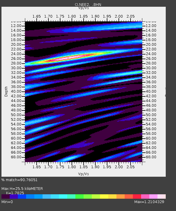
| Estimated Moho Depth: |
25.5 km |
| Estimated Crust Vp/Vs: |
1.78 |
| Assumed Crust Vp: |
6.276 km/s |
| Estimated Crust Vs: |
3.521 km/s |
| Estimated Crust Poisson's Ratio: |
0.27 |
|
| Radial Match: |
90.76051 % |
| Radial Bump: |
400 |
| Transverse Match: |
89.11617 % |
| Transverse Bump: |
400 |
| SOD ConfigId: |
2564 |
| Insert Time: |
2010-02-26 00:22:08.646 +0000 |
| GWidth: |
2.5 |
| Max Bumps: |
400 |
| Tol: |
0.001 |
|

Signal To Noise
| Channel | StoN | STA | LTA |
| CI:NEE2: :BHN:20071016T21:17:01.220012Z | 9.942216 | 1.5147809E-6 | 1.523585E-7 |
| CI:NEE2: :BHE:20071016T21:17:01.220012Z | 8.3107395 | 1.6208575E-6 | 1.9503169E-7 |
| CI:NEE2: :BHZ:20071016T21:17:01.220012Z | 23.513096 | 6.6763264E-6 | 2.8394075E-7 |
| Arrivals |
| Ps | 3.2 SECOND |
| PpPs | 11 SECOND |
| PsPs/PpSs | 14 SECOND |


