You are here: Home > Network List > US - United States National Seismic Network Stations List
> Station ACSO Alum Creek State Park, Ohio, USA > Earthquake Result Viewer
ACSO Alum Creek State Park, Ohio, USA - Earthquake Result Viewer
| Earthquake location: |
Windward Islands |
| Earthquake latitude/longitude: |
15.0/-61.3 |
| Earthquake time(UTC): |
2007/11/29 (333) 19:00:19 GMT |
| Earthquake Depth: |
148 km |
| Earthquake Magnitude: |
6.9 MB, 7.4 MW, 7.4 MW |
| Earthquake Catalog/Contributor: |
WHDF/NEIC |
|
| Network: |
US United States National Seismic Network |
| Station: |
ACSO Alum Creek State Park, Ohio, USA |
| Lat/Lon: |
40.23 N/82.98 W |
| Elevation: |
288 m |
|
| Distance: |
31.5 deg |
| Az: |
327.175 deg |
| Baz: |
136.817 deg |
| Ray Param: |
0.07862659 |
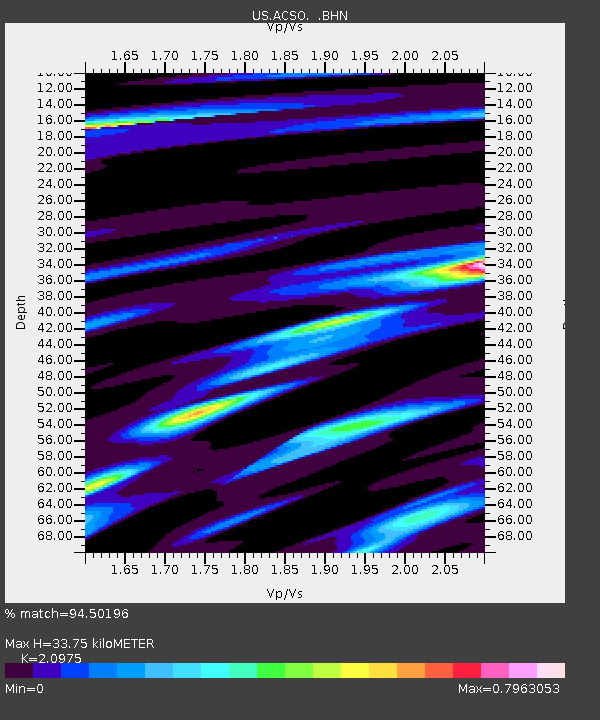
| Estimated Moho Depth: |
33.75 km |
| Estimated Crust Vp/Vs: |
2.10 |
| Assumed Crust Vp: |
6.498 km/s |
| Estimated Crust Vs: |
3.098 km/s |
| Estimated Crust Poisson's Ratio: |
0.35 |
|
| Radial Match: |
94.50196 % |
| Radial Bump: |
213 |
| Transverse Match: |
82.44692 % |
| Transverse Bump: |
393 |
| SOD ConfigId: |
2564 |
| Insert Time: |
2010-03-05 03:09:06.451 +0000 |
| GWidth: |
2.5 |
| Max Bumps: |
400 |
| Tol: |
0.001 |
|
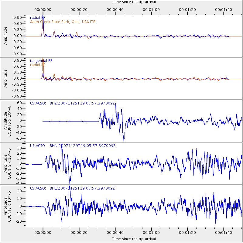
Signal To Noise
| Channel | StoN | STA | LTA |
| US:ACSO: :BHN:20071129T19:05:57.397009Z | 14.961226 | 8.3021105E-6 | 5.549084E-7 |
| US:ACSO: :BHE:20071129T19:05:57.397009Z | 10.888425 | 4.9007735E-6 | 4.500902E-7 |
| US:ACSO: :BHZ:20071129T19:05:57.397009Z | 39.302547 | 1.5419077E-5 | 3.9231747E-7 |
| Arrivals |
| Ps | 6.1 SECOND |
| PpPs | 15 SECOND |
| PsPs/PpSs | 21 SECOND |


