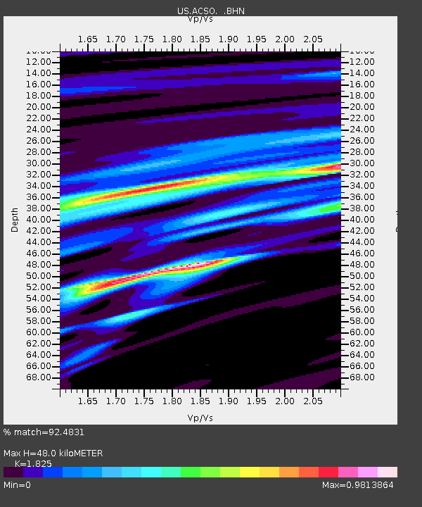
ACSO Alum Creek State Park, Ohio, USA - Earthquake Result Viewer

Earthquake location: Andreanof Islands, Aleutian Is.
Earthquake latitude/longitude: 50.3/-177.5
Earthquake time(UTC): 2007/08/15 (227) 20:22:11 GMT
Earthquake Depth: 9.0 km
Earthquake Magnitude: 6.3 MB, 6.2 MS, 6.4 MW, 5.9 ML
Earthquake Catalog/Contributor: WHDF/NEIC
Network: US United States National Seismic Network
Station: ACSO Alum Creek State Park, Ohio, USA
Lat/Lon: 40.23 N/82.98 W
Elevation: 288 m
Distance: 63.0 deg
Az: 58.965 deg
Baz: 314.156 deg
Ray Param: 0.05989346
Estimated Moho Depth: 48.0 km
Estimated Crust Vp/Vs: 1.83
Assumed Crust Vp: 6.498 km/s
Estimated Crust Vs: 3.56 km/s
Estimated Crust Poisson's Ratio: 0.29
Radial Match: 92.4831 %
Radial Bump: 400
Transverse Match: 70.87543 %
Transverse Bump: 400
SOD ConfigId: 2564
Insert Time: 2010-03-05 03:09:23.872 +0000
GWidth: 2.5
Max Bumps: 400
Tol: 0.001

Signal To Noise

ChannelStoNSTALTA
US:ACSO: :BHN:20070815T20:32:06.750005Z6.84286931.3816177E-62.019062E-7
US:ACSO: :BHE:20070815T20:32:06.750005Z2.63001428.779083E-73.3380363E-7
US:ACSO: :BHZ:20070815T20:32:06.750005Z38.351453.4216118E-68.9217274E-8
Arrivals
Ps6.4 SECOND
PpPs20 SECOND
PsPs/PpSs26 SECOND