You are here: Home > Network List > TA - USArray Transportable Network (new EarthScope stations) Stations List
> Station L44A Lake County Forest Preserve, Grayslake, IL, USA > Earthquake Result Viewer
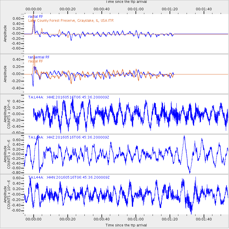
L44A Lake County Forest Preserve, Grayslake, IL, USA - Earthquake Result Viewer
*The percent match for this event was below the threshold and hence no stack was calculated.
| Earthquake location: |
Northern East Pacific Rise |
| Earthquake latitude/longitude: |
8.5/-103.1 |
| Earthquake time(UTC): |
2016/05/16 (137) 06:39:04 GMT |
| Earthquake Depth: |
10 km |
| Earthquake Magnitude: |
5.5 mwc |
| Earthquake Catalog/Contributor: |
NEIC PDE/us |
|
| Network: |
TA USArray Transportable Network (new EarthScope stations) |
| Station: |
L44A Lake County Forest Preserve, Grayslake, IL, USA |
| Lat/Lon: |
42.18 N/87.91 W |
| Elevation: |
202 m |
|
| Distance: |
36.1 deg |
| Az: |
19.306 deg |
| Baz: |
206.101 deg |
| Ray Param: |
$rayparam |
*The percent match for this event was below the threshold and hence was not used in the summary stack. |
|
| Radial Match: |
57.76646 % |
| Radial Bump: |
400 |
| Transverse Match: |
59.908978 % |
| Transverse Bump: |
400 |
| SOD ConfigId: |
7422571 |
| Insert Time: |
2019-04-22 14:30:41.651 +0000 |
| GWidth: |
2.5 |
| Max Bumps: |
400 |
| Tol: |
0.001 |
|
Signal To Noise
| Channel | StoN | STA | LTA |
| TA:L44A: :HHZ:20160516T06:45:36.200009Z | 2.2816389 | 5.239586E-7 | 2.2964134E-7 |
| TA:L44A: :HHN:20160516T06:45:36.200009Z | 1.6103128 | 2.9233124E-7 | 1.8153692E-7 |
| TA:L44A: :HHE:20160516T06:45:36.200009Z | 1.2873132 | 2.7154658E-7 | 2.1094057E-7 |
| Arrivals |
| Ps | |
| PpPs | |
| PsPs/PpSs | |


