You are here: Home > Network List > US - United States National Seismic Network Stations List
> Station AMTX Amarillo, Texas, USA > Earthquake Result Viewer
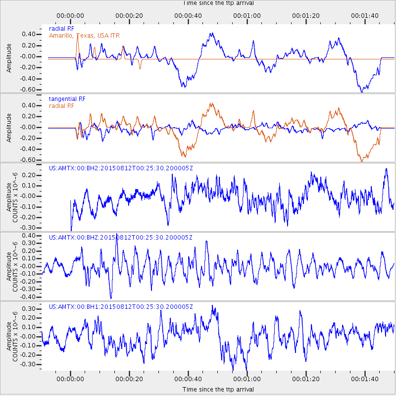
AMTX Amarillo, Texas, USA - Earthquake Result Viewer
*The percent match for this event was below the threshold and hence no stack was calculated.
| Earthquake location: |
Near Coast Of Central Chile |
| Earthquake latitude/longitude: |
-31.7/-71.6 |
| Earthquake time(UTC): |
2015/08/12 (224) 00:14:40 GMT |
| Earthquake Depth: |
30 km |
| Earthquake Magnitude: |
5.5 MWW, 5.3 MWR, 5.4 MWB |
| Earthquake Catalog/Contributor: |
NEIC PDE/NEIC COMCAT |
|
| Network: |
US United States National Seismic Network |
| Station: |
AMTX Amarillo, Texas, USA |
| Lat/Lon: |
34.53 N/101.41 W |
| Elevation: |
1010 m |
|
| Distance: |
71.6 deg |
| Az: |
334.391 deg |
| Baz: |
153.495 deg |
| Ray Param: |
$rayparam |
*The percent match for this event was below the threshold and hence was not used in the summary stack. |
|
| Radial Match: |
47.83913 % |
| Radial Bump: |
400 |
| Transverse Match: |
55.45677 % |
| Transverse Bump: |
400 |
| SOD ConfigId: |
1085051 |
| Insert Time: |
2015-09-01 00:48:09.820 +0000 |
| GWidth: |
2.5 |
| Max Bumps: |
400 |
| Tol: |
0.001 |
|
Signal To Noise
| Channel | StoN | STA | LTA |
| US:AMTX:00:BHZ:20150812T00:25:30.200005Z | 1.0441382 | 1.0990841E-7 | 1.0526233E-7 |
| US:AMTX:00:BH1:20150812T00:25:30.200005Z | 0.6188486 | 6.008311E-8 | 9.708854E-8 |
| US:AMTX:00:BH2:20150812T00:25:30.200005Z | 1.3680416 | 1.1112791E-7 | 8.1231384E-8 |
| Arrivals |
| Ps | |
| PpPs | |
| PsPs/PpSs | |


