You are here: Home > Network List > 7A - Mid-Atlantic Geophysical Integrative Collaboration Stations List
> Station LBDL Montpelier, Virginia USA > Earthquake Result Viewer
LBDL Montpelier, Virginia USA - Earthquake Result Viewer
| Earthquake location: |
Near Coast Of Ecuador |
| Earthquake latitude/longitude: |
0.4/-79.8 |
| Earthquake time(UTC): |
2016/05/18 (139) 07:57:05 GMT |
| Earthquake Depth: |
32 km |
| Earthquake Magnitude: |
6.7 MWP, 6.7 MWW, 6.7 MI |
| Earthquake Catalog/Contributor: |
NEIC PDE/NEIC COMCAT |
|
| Network: |
7A Mid-Atlantic Geophysical Integrative Collaboration |
| Station: |
LBDL Montpelier, Virginia USA |
| Lat/Lon: |
37.80 N/77.64 W |
| Elevation: |
48 m |
|
| Distance: |
37.2 deg |
| Az: |
2.782 deg |
| Baz: |
183.513 deg |
| Ray Param: |
0.07618444 |
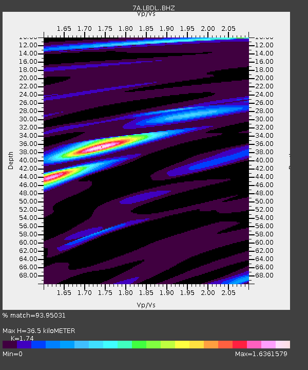
| Estimated Moho Depth: |
36.5 km |
| Estimated Crust Vp/Vs: |
1.74 |
| Assumed Crust Vp: |
6.565 km/s |
| Estimated Crust Vs: |
3.773 km/s |
| Estimated Crust Poisson's Ratio: |
0.25 |
|
| Radial Match: |
93.95031 % |
| Radial Bump: |
286 |
| Transverse Match: |
77.4545 % |
| Transverse Bump: |
400 |
| SOD ConfigId: |
7422571 |
| Insert Time: |
2019-04-22 14:32:47.156 +0000 |
| GWidth: |
2.5 |
| Max Bumps: |
400 |
| Tol: |
0.001 |
|

Signal To Noise
| Channel | StoN | STA | LTA |
| 7A:LBDL: :BHZ:20160518T08:03:42.600007Z | 28.628418 | 4.551826E-6 | 1.5899677E-7 |
| 7A:LBDL: :BHN:20160518T08:03:42.600007Z | 17.083586 | 2.6754321E-6 | 1.5660835E-7 |
| 7A:LBDL: :BHE:20160518T08:03:42.600007Z | 6.8898354 | 6.339286E-7 | 9.200925E-8 |
| Arrivals |
| Ps | 4.5 SECOND |
| PpPs | 14 SECOND |
| PsPs/PpSs | 19 SECOND |


