You are here: Home > Network List > 7A - Mid-Atlantic Geophysical Integrative Collaboration Stations List
> Station PAUL Paulding, Ohio USA > Earthquake Result Viewer
PAUL Paulding, Ohio USA - Earthquake Result Viewer
| Earthquake location: |
Near Coast Of Ecuador |
| Earthquake latitude/longitude: |
0.4/-79.8 |
| Earthquake time(UTC): |
2016/05/18 (139) 07:57:05 GMT |
| Earthquake Depth: |
32 km |
| Earthquake Magnitude: |
6.7 MWP, 6.7 MWW, 6.7 MI |
| Earthquake Catalog/Contributor: |
NEIC PDE/NEIC COMCAT |
|
| Network: |
7A Mid-Atlantic Geophysical Integrative Collaboration |
| Station: |
PAUL Paulding, Ohio USA |
| Lat/Lon: |
41.14 N/84.55 W |
| Elevation: |
0.0 m |
|
| Distance: |
40.8 deg |
| Az: |
354.464 deg |
| Baz: |
172.662 deg |
| Ray Param: |
0.07415285 |
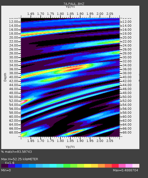
| Estimated Moho Depth: |
52.25 km |
| Estimated Crust Vp/Vs: |
1.60 |
| Assumed Crust Vp: |
6.498 km/s |
| Estimated Crust Vs: |
4.061 km/s |
| Estimated Crust Poisson's Ratio: |
0.18 |
|
| Radial Match: |
93.59743 % |
| Radial Bump: |
311 |
| Transverse Match: |
76.32105 % |
| Transverse Bump: |
400 |
| SOD ConfigId: |
7422571 |
| Insert Time: |
2019-04-22 14:32:49.095 +0000 |
| GWidth: |
2.5 |
| Max Bumps: |
400 |
| Tol: |
0.001 |
|

Signal To Noise
| Channel | StoN | STA | LTA |
| 7A:PAUL: :BHZ:20160518T08:04:11.91501Z | 13.222885 | 2.6872774E-6 | 2.0322928E-7 |
| 7A:PAUL: :BHN:20160518T08:04:11.91501Z | 10.240397 | 1.3071962E-6 | 1.2765092E-7 |
| 7A:PAUL: :BHE:20160518T08:04:11.91501Z | 2.3984876 | 3.2910742E-7 | 1.3721456E-7 |
| Arrivals |
| Ps | 5.2 SECOND |
| PpPs | 19 SECOND |
| PsPs/PpSs | 25 SECOND |


