You are here: Home > Network List > AK - Alaska Regional Network Stations List
> Station CUT Chulitna, AK, USA > Earthquake Result Viewer
CUT Chulitna, AK, USA - Earthquake Result Viewer
| Earthquake location: |
Near Coast Of Ecuador |
| Earthquake latitude/longitude: |
0.4/-79.8 |
| Earthquake time(UTC): |
2016/05/18 (139) 07:57:05 GMT |
| Earthquake Depth: |
32 km |
| Earthquake Magnitude: |
6.7 MWP, 6.7 MWW, 6.7 MI |
| Earthquake Catalog/Contributor: |
NEIC PDE/NEIC COMCAT |
|
| Network: |
AK Alaska Regional Network |
| Station: |
CUT Chulitna, AK, USA |
| Lat/Lon: |
62.41 N/150.26 W |
| Elevation: |
574 m |
|
| Distance: |
80.7 deg |
| Az: |
333.589 deg |
| Baz: |
107.211 deg |
| Ray Param: |
0.048072353 |
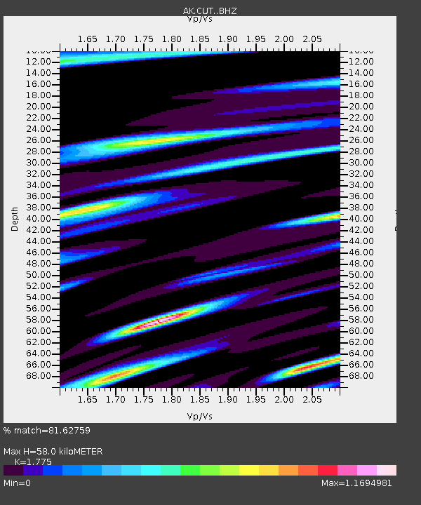
| Estimated Moho Depth: |
58.0 km |
| Estimated Crust Vp/Vs: |
1.77 |
| Assumed Crust Vp: |
6.438 km/s |
| Estimated Crust Vs: |
3.627 km/s |
| Estimated Crust Poisson's Ratio: |
0.27 |
|
| Radial Match: |
81.62759 % |
| Radial Bump: |
366 |
| Transverse Match: |
77.473595 % |
| Transverse Bump: |
393 |
| SOD ConfigId: |
7422571 |
| Insert Time: |
2019-04-22 14:33:26.702 +0000 |
| GWidth: |
2.5 |
| Max Bumps: |
400 |
| Tol: |
0.001 |
|

Signal To Noise
| Channel | StoN | STA | LTA |
| AK:CUT: :BHZ:20160518T08:08:43.280Z | 11.052237 | 2.054513E-6 | 1.8589117E-7 |
| AK:CUT: :BHN:20160518T08:08:43.280Z | 1.8009077 | 5.712931E-7 | 3.1722507E-7 |
| AK:CUT: :BHE:20160518T08:08:43.280Z | 4.20559 | 1.1202409E-6 | 2.663695E-7 |
| Arrivals |
| Ps | 7.2 SECOND |
| PpPs | 24 SECOND |
| PsPs/PpSs | 31 SECOND |


