You are here: Home > Network List > AK - Alaska Regional Network Stations List
> Station TNA Tin City Broadband > Earthquake Result Viewer
TNA Tin City Broadband - Earthquake Result Viewer
| Earthquake location: |
Near Coast Of Ecuador |
| Earthquake latitude/longitude: |
0.4/-79.8 |
| Earthquake time(UTC): |
2016/05/18 (139) 07:57:05 GMT |
| Earthquake Depth: |
32 km |
| Earthquake Magnitude: |
6.7 MWP, 6.7 MWW, 6.7 MI |
| Earthquake Catalog/Contributor: |
NEIC PDE/NEIC COMCAT |
|
| Network: |
AK Alaska Regional Network |
| Station: |
TNA Tin City Broadband |
| Lat/Lon: |
65.56 N/167.92 W |
| Elevation: |
74 m |
|
| Distance: |
88.8 deg |
| Az: |
335.424 deg |
| Baz: |
91.497 deg |
| Ray Param: |
0.042240612 |
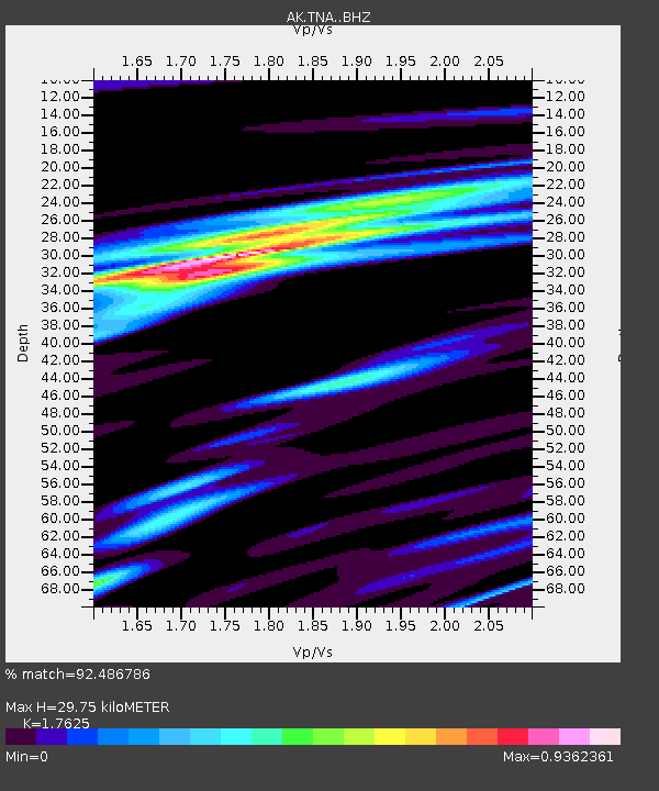
| Estimated Moho Depth: |
29.75 km |
| Estimated Crust Vp/Vs: |
1.76 |
| Assumed Crust Vp: |
6.307 km/s |
| Estimated Crust Vs: |
3.578 km/s |
| Estimated Crust Poisson's Ratio: |
0.26 |
|
| Radial Match: |
92.486786 % |
| Radial Bump: |
373 |
| Transverse Match: |
78.146286 % |
| Transverse Bump: |
400 |
| SOD ConfigId: |
7422571 |
| Insert Time: |
2019-04-22 14:34:09.489 +0000 |
| GWidth: |
2.5 |
| Max Bumps: |
400 |
| Tol: |
0.001 |
|

Signal To Noise
| Channel | StoN | STA | LTA |
| AK:TNA: :BHZ:20160518T08:09:24.308015Z | 8.913784 | 1.6321319E-6 | 1.8310203E-7 |
| AK:TNA: :BHN:20160518T08:09:24.308015Z | 1.384274 | 1.7320313E-7 | 1.25122E-7 |
| AK:TNA: :BHE:20160518T08:09:24.308015Z | 3.9757931 | 6.03675E-7 | 1.5183763E-7 |
| Arrivals |
| Ps | 3.7 SECOND |
| PpPs | 13 SECOND |
| PsPs/PpSs | 16 SECOND |


