You are here: Home > Network List > US - United States National Seismic Network Stations List
> Station ACSO Alum Creek State Park, Ohio, USA > Earthquake Result Viewer
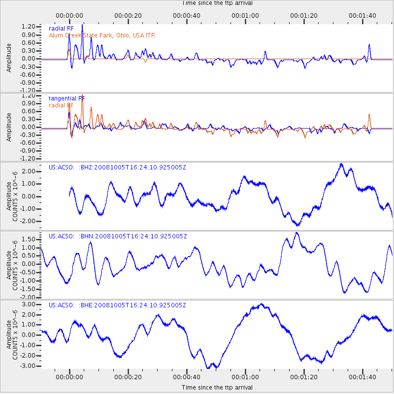
ACSO Alum Creek State Park, Ohio, USA - Earthquake Result Viewer
*The percent match for this event was below the threshold and hence no stack was calculated.
| Earthquake location: |
Tajikistan-Xinjiang Border Reg. |
| Earthquake latitude/longitude: |
39.5/73.9 |
| Earthquake time(UTC): |
2008/10/05 (279) 16:11:10 GMT |
| Earthquake Depth: |
35 km |
| Earthquake Magnitude: |
5.6 MB |
| Earthquake Catalog/Contributor: |
WHDF/NEIC |
|
| Network: |
US United States National Seismic Network |
| Station: |
ACSO Alum Creek State Park, Ohio, USA |
| Lat/Lon: |
40.23 N/82.98 W |
| Elevation: |
288 m |
|
| Distance: |
97.9 deg |
| Az: |
342.326 deg |
| Baz: |
17.866 deg |
| Ray Param: |
$rayparam |
*The percent match for this event was below the threshold and hence was not used in the summary stack. |
|
| Radial Match: |
62.423557 % |
| Radial Bump: |
338 |
| Transverse Match: |
41.960842 % |
| Transverse Bump: |
400 |
| SOD ConfigId: |
2560 |
| Insert Time: |
2010-03-05 03:10:48.322 +0000 |
| GWidth: |
2.5 |
| Max Bumps: |
400 |
| Tol: |
0.001 |
|
Signal To Noise
| Channel | StoN | STA | LTA |
| US:ACSO: :BHN:20081005T16:24:10.925005Z | 1.5995507 | 6.416034E-7 | 4.0111473E-7 |
| US:ACSO: :BHE:20081005T16:24:10.925005Z | 2.3336585 | 1.1404932E-6 | 4.887147E-7 |
| US:ACSO: :BHZ:20081005T16:24:10.925005Z | 0.8400113 | 5.7413934E-7 | 6.8349E-7 |
| Arrivals |
| Ps | |
| PpPs | |
| PsPs/PpSs | |


