You are here: Home > Network List > C1 - Red Sismologica Nacional Stations List
> Station MT01 Daracena > Earthquake Result Viewer
MT01 Daracena - Earthquake Result Viewer
| Earthquake location: |
Near Coast Of Ecuador |
| Earthquake latitude/longitude: |
0.4/-79.8 |
| Earthquake time(UTC): |
2016/05/18 (139) 07:57:05 GMT |
| Earthquake Depth: |
32 km |
| Earthquake Magnitude: |
6.7 MWP, 6.7 MWW, 6.7 MI |
| Earthquake Catalog/Contributor: |
NEIC PDE/NEIC COMCAT |
|
| Network: |
C1 Red Sismologica Nacional |
| Station: |
MT01 Daracena |
| Lat/Lon: |
33.86 S/71.25 W |
| Elevation: |
310 m |
|
| Distance: |
35.0 deg |
| Az: |
167.609 deg |
| Baz: |
345.056 deg |
| Ray Param: |
0.0773744 |
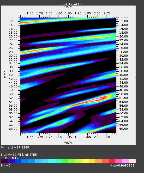
| Estimated Moho Depth: |
52.75 km |
| Estimated Crust Vp/Vs: |
1.99 |
| Assumed Crust Vp: |
6.481 km/s |
| Estimated Crust Vs: |
3.265 km/s |
| Estimated Crust Poisson's Ratio: |
0.33 |
|
| Radial Match: |
87.3289 % |
| Radial Bump: |
384 |
| Transverse Match: |
73.828674 % |
| Transverse Bump: |
400 |
| SOD ConfigId: |
7422571 |
| Insert Time: |
2019-04-22 14:35:19.783 +0000 |
| GWidth: |
2.5 |
| Max Bumps: |
400 |
| Tol: |
0.001 |
|

Signal To Noise
| Channel | StoN | STA | LTA |
| C1:MT01: :HHZ:20160518T08:03:23.799012Z | 19.458588 | 2.9931612E-6 | 1.5382211E-7 |
| C1:MT01: :HHN:20160518T08:03:23.799012Z | 11.277666 | 1.8011166E-6 | 1.5970649E-7 |
| C1:MT01: :HHE:20160518T08:03:23.799012Z | 2.5174332 | 4.3029692E-7 | 1.7092684E-7 |
| Arrivals |
| Ps | 8.6 SECOND |
| PpPs | 23 SECOND |
| PsPs/PpSs | 31 SECOND |


