You are here: Home > Network List > CI - Caltech Regional Seismic Network Stations List
> Station SWS Sam W. Stewart, Westmorland, CA, USA > Earthquake Result Viewer
SWS Sam W. Stewart, Westmorland, CA, USA - Earthquake Result Viewer
| Earthquake location: |
Near Coast Of Ecuador |
| Earthquake latitude/longitude: |
0.4/-79.8 |
| Earthquake time(UTC): |
2016/05/18 (139) 07:57:05 GMT |
| Earthquake Depth: |
32 km |
| Earthquake Magnitude: |
6.7 MWP, 6.7 MWW, 6.7 MI |
| Earthquake Catalog/Contributor: |
NEIC PDE/NEIC COMCAT |
|
| Network: |
CI Caltech Regional Seismic Network |
| Station: |
SWS Sam W. Stewart, Westmorland, CA, USA |
| Lat/Lon: |
32.94 N/115.80 W |
| Elevation: |
140 m |
|
| Distance: |
46.8 deg |
| Az: |
317.306 deg |
| Baz: |
126.258 deg |
| Ray Param: |
0.070322335 |
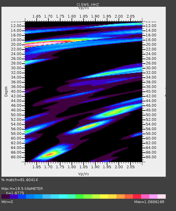
| Estimated Moho Depth: |
19.5 km |
| Estimated Crust Vp/Vs: |
1.68 |
| Assumed Crust Vp: |
6.155 km/s |
| Estimated Crust Vs: |
3.669 km/s |
| Estimated Crust Poisson's Ratio: |
0.22 |
|
| Radial Match: |
91.60414 % |
| Radial Bump: |
400 |
| Transverse Match: |
80.376274 % |
| Transverse Bump: |
400 |
| SOD ConfigId: |
7422571 |
| Insert Time: |
2019-04-22 14:36:26.443 +0000 |
| GWidth: |
2.5 |
| Max Bumps: |
400 |
| Tol: |
0.001 |
|
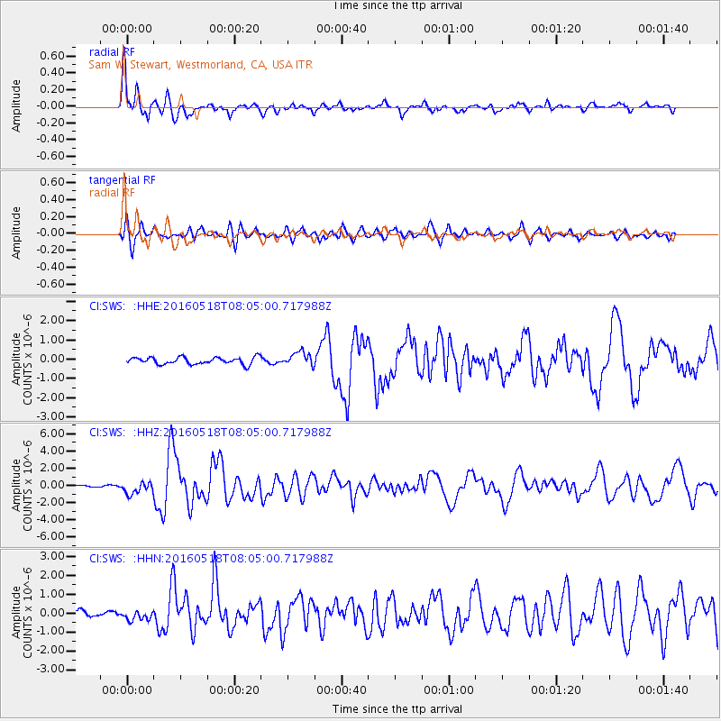
Signal To Noise
| Channel | StoN | STA | LTA |
| CI:SWS: :HHZ:20160518T08:05:00.717988Z | 6.7240667 | 7.033556E-7 | 1.04602705E-7 |
| CI:SWS: :HHN:20160518T08:05:00.717988Z | 1.7216098 | 2.7456872E-7 | 1.5948372E-7 |
| CI:SWS: :HHE:20160518T08:05:00.717988Z | 1.9994233 | 3.6212447E-7 | 1.8111447E-7 |
| Arrivals |
| Ps | 2.3 SECOND |
| PpPs | 8.0 SECOND |
| PsPs/PpSs | 10 SECOND |


