You are here: Home > Network List > GB - Great Britain Seismograph Network Stations List
> Station ELSH ELHAM, ENGLAND > Earthquake Result Viewer
ELSH ELHAM, ENGLAND - Earthquake Result Viewer
| Earthquake location: |
Near Coast Of Ecuador |
| Earthquake latitude/longitude: |
0.4/-79.8 |
| Earthquake time(UTC): |
2016/05/18 (139) 07:57:05 GMT |
| Earthquake Depth: |
32 km |
| Earthquake Magnitude: |
6.7 MWP, 6.7 MWW, 6.7 MI |
| Earthquake Catalog/Contributor: |
NEIC PDE/NEIC COMCAT |
|
| Network: |
GB Great Britain Seismograph Network |
| Station: |
ELSH ELHAM, ENGLAND |
| Lat/Lon: |
51.15 N/1.14 E |
| Elevation: |
129 m |
|
| Distance: |
84.0 deg |
| Az: |
38.714 deg |
| Baz: |
263.177 deg |
| Ray Param: |
0.045779627 |
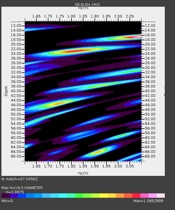
| Estimated Moho Depth: |
16.5 km |
| Estimated Crust Vp/Vs: |
2.10 |
| Assumed Crust Vp: |
6.207 km/s |
| Estimated Crust Vs: |
2.959 km/s |
| Estimated Crust Poisson's Ratio: |
0.35 |
|
| Radial Match: |
87.04582 % |
| Radial Bump: |
400 |
| Transverse Match: |
83.06376 % |
| Transverse Bump: |
400 |
| SOD ConfigId: |
7422571 |
| Insert Time: |
2019-04-22 14:37:47.129 +0000 |
| GWidth: |
2.5 |
| Max Bumps: |
400 |
| Tol: |
0.001 |
|

Signal To Noise
| Channel | StoN | STA | LTA |
| GB:ELSH: :HHZ:20160518T08:09:00.470002Z | 16.561644 | 3.744227E-6 | 2.2607823E-7 |
| GB:ELSH: :HHN:20160518T08:09:00.470002Z | 1.7967607 | 7.066834E-7 | 3.933097E-7 |
| GB:ELSH: :HHE:20160518T08:09:00.470002Z | 6.5609217 | 2.1561618E-6 | 3.2863704E-7 |
| Arrivals |
| Ps | 3.0 SECOND |
| PpPs | 8.1 SECOND |
| PsPs/PpSs | 11 SECOND |


