You are here: Home > Network List > GB - Great Britain Seismograph Network Stations List
> Station MCH1 MICHAELCHURCH, WALES > Earthquake Result Viewer
MCH1 MICHAELCHURCH, WALES - Earthquake Result Viewer
| Earthquake location: |
Near Coast Of Ecuador |
| Earthquake latitude/longitude: |
0.4/-79.8 |
| Earthquake time(UTC): |
2016/05/18 (139) 07:57:05 GMT |
| Earthquake Depth: |
32 km |
| Earthquake Magnitude: |
6.7 MWP, 6.7 MWW, 6.7 MI |
| Earthquake Catalog/Contributor: |
NEIC PDE/NEIC COMCAT |
|
| Network: |
GB Great Britain Seismograph Network |
| Station: |
MCH1 MICHAELCHURCH, WALES |
| Lat/Lon: |
52.00 N/3.00 W |
| Elevation: |
219 m |
|
| Distance: |
81.5 deg |
| Az: |
37.48 deg |
| Baz: |
259.79 deg |
| Ray Param: |
0.047481004 |
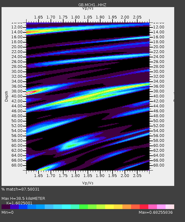
| Estimated Moho Depth: |
38.5 km |
| Estimated Crust Vp/Vs: |
1.60 |
| Assumed Crust Vp: |
6.182 km/s |
| Estimated Crust Vs: |
3.858 km/s |
| Estimated Crust Poisson's Ratio: |
0.18 |
|
| Radial Match: |
87.58031 % |
| Radial Bump: |
334 |
| Transverse Match: |
73.275345 % |
| Transverse Bump: |
400 |
| SOD ConfigId: |
7422571 |
| Insert Time: |
2019-04-22 14:37:59.265 +0000 |
| GWidth: |
2.5 |
| Max Bumps: |
400 |
| Tol: |
0.001 |
|

Signal To Noise
| Channel | StoN | STA | LTA |
| GB:MCH1: :HHZ:20160518T08:08:47.920015Z | 11.813368 | 6.0179837E-6 | 5.094215E-7 |
| GB:MCH1: :HHN:20160518T08:08:47.920015Z | 1.5258152 | 6.966141E-7 | 4.5655207E-7 |
| GB:MCH1: :HHE:20160518T08:08:47.920015Z | 7.787468 | 1.6862593E-6 | 2.1653499E-7 |
| Arrivals |
| Ps | 3.9 SECOND |
| PpPs | 16 SECOND |
| PsPs/PpSs | 20 SECOND |


