You are here: Home > Network List > LD - Lamont-Doherty Cooperative Seismographic Network Stations List
> Station WUPA West Chester University of Pennsylvania > Earthquake Result Viewer
WUPA West Chester University of Pennsylvania - Earthquake Result Viewer
| Earthquake location: |
Near Coast Of Ecuador |
| Earthquake latitude/longitude: |
0.4/-79.8 |
| Earthquake time(UTC): |
2016/05/18 (139) 07:57:05 GMT |
| Earthquake Depth: |
32 km |
| Earthquake Magnitude: |
6.7 MWP, 6.7 MWW, 6.7 MI |
| Earthquake Catalog/Contributor: |
NEIC PDE/NEIC COMCAT |
|
| Network: |
LD Lamont-Doherty Cooperative Seismographic Network |
| Station: |
WUPA West Chester University of Pennsylvania |
| Lat/Lon: |
39.93 N/75.61 W |
| Elevation: |
86 m |
|
| Distance: |
39.5 deg |
| Az: |
5.03 deg |
| Baz: |
186.547 deg |
| Ray Param: |
0.07488673 |
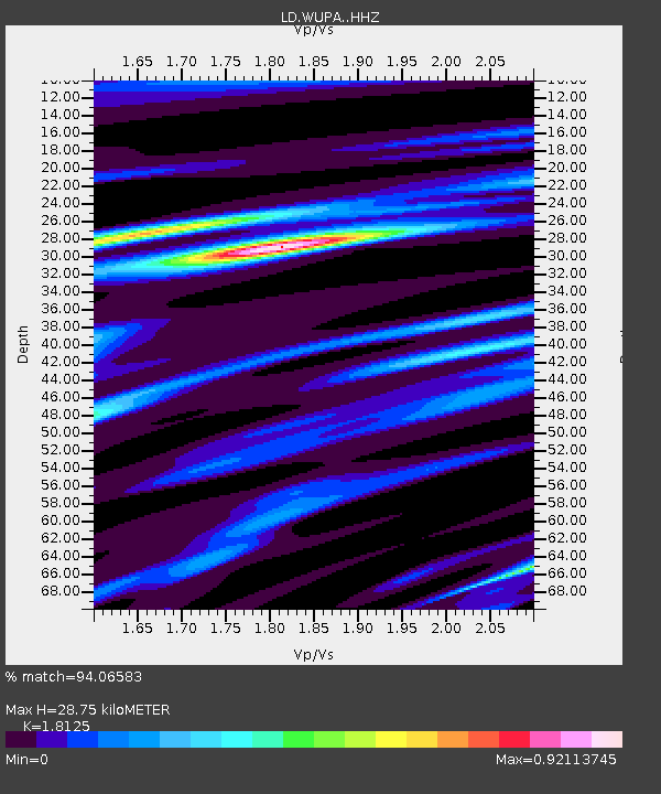
| Estimated Moho Depth: |
28.75 km |
| Estimated Crust Vp/Vs: |
1.81 |
| Assumed Crust Vp: |
6.287 km/s |
| Estimated Crust Vs: |
3.469 km/s |
| Estimated Crust Poisson's Ratio: |
0.28 |
|
| Radial Match: |
94.06583 % |
| Radial Bump: |
306 |
| Transverse Match: |
74.93368 % |
| Transverse Bump: |
400 |
| SOD ConfigId: |
7422571 |
| Insert Time: |
2019-04-22 14:39:02.944 +0000 |
| GWidth: |
2.5 |
| Max Bumps: |
400 |
| Tol: |
0.001 |
|

Signal To Noise
| Channel | StoN | STA | LTA |
| LD:WUPA: :HHZ:20160518T08:04:01.589998Z | 31.478292 | 2.6794594E-6 | 8.512087E-8 |
| LD:WUPA: :HHN:20160518T08:04:01.589998Z | 33.096146 | 1.6265981E-6 | 4.914766E-8 |
| LD:WUPA: :HHE:20160518T08:04:01.589998Z | 5.281338 | 2.324164E-7 | 4.4007106E-8 |
| Arrivals |
| Ps | 4.0 SECOND |
| PpPs | 12 SECOND |
| PsPs/PpSs | 16 SECOND |


