You are here: Home > Network List > N4 - Central and EAstern US Network Stations List
> Station E28B Huff Hills, Mandan, ND, USA > Earthquake Result Viewer
E28B Huff Hills, Mandan, ND, USA - Earthquake Result Viewer
| Earthquake location: |
Near Coast Of Ecuador |
| Earthquake latitude/longitude: |
0.4/-79.8 |
| Earthquake time(UTC): |
2016/05/18 (139) 07:57:05 GMT |
| Earthquake Depth: |
32 km |
| Earthquake Magnitude: |
6.7 MWP, 6.7 MWW, 6.7 MI |
| Earthquake Catalog/Contributor: |
NEIC PDE/NEIC COMCAT |
|
| Network: |
N4 Central and EAstern US Network |
| Station: |
E28B Huff Hills, Mandan, ND, USA |
| Lat/Lon: |
46.57 N/100.69 W |
| Elevation: |
704 m |
|
| Distance: |
49.5 deg |
| Az: |
341.087 deg |
| Baz: |
151.975 deg |
| Ray Param: |
0.06861175 |
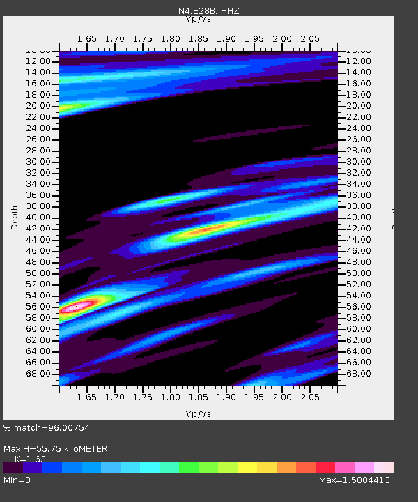
| Estimated Moho Depth: |
55.75 km |
| Estimated Crust Vp/Vs: |
1.63 |
| Assumed Crust Vp: |
6.438 km/s |
| Estimated Crust Vs: |
3.949 km/s |
| Estimated Crust Poisson's Ratio: |
0.20 |
|
| Radial Match: |
96.00754 % |
| Radial Bump: |
285 |
| Transverse Match: |
85.964195 % |
| Transverse Bump: |
299 |
| SOD ConfigId: |
7422571 |
| Insert Time: |
2019-04-22 14:39:29.877 +0000 |
| GWidth: |
2.5 |
| Max Bumps: |
400 |
| Tol: |
0.001 |
|

Signal To Noise
| Channel | StoN | STA | LTA |
| N4:E28B: :HHZ:20160518T08:05:21.130006Z | 41.978836 | 4.4033313E-6 | 1.0489408E-7 |
| N4:E28B: :HHN:20160518T08:05:21.130006Z | 6.4829607 | 3.6861081E-6 | 5.68584E-7 |
| N4:E28B: :HHE:20160518T08:05:21.130006Z | 4.4354677 | 1.990355E-6 | 4.4873622E-7 |
| Arrivals |
| Ps | 5.8 SECOND |
| PpPs | 21 SECOND |
| PsPs/PpSs | 27 SECOND |


