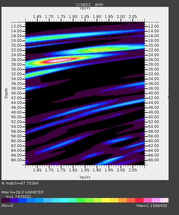
NEE2 Needles Airport - Earthquake Result Viewer

Earthquake location: Near Coast Of Peru
Earthquake latitude/longitude: -13.4/-76.6
Earthquake time(UTC): 2007/08/15 (227) 23:40:57 GMT
Earthquake Depth: 39 km
Earthquake Magnitude: 6.7 MB, 7.9 MS, 8.0 MW, 7.5 ME
Earthquake Catalog/Contributor: WHDF/NEIC
Network: CI Caltech Regional Seismic Network
Station: NEE2 Needles Airport
Lat/Lon: 34.77 N/114.62 W
Elevation: 271 m
Distance: 60.0 deg
Az: 324.147 deg
Baz: 136.182 deg
Ray Param: 0.061771564
Estimated Moho Depth: 26.0 km
Estimated Crust Vp/Vs: 1.74
Assumed Crust Vp: 6.276 km/s
Estimated Crust Vs: 3.602 km/s
Estimated Crust Poisson's Ratio: 0.25
Radial Match: 97.75364 %
Radial Bump: 345
Transverse Match: 85.09471 %
Transverse Bump: 400
SOD ConfigId: 2564
Insert Time: 2010-02-26 00:22:30.503 +0000
GWidth: 2.5
Max Bumps: 400
Tol: 0.001

Signal To Noise

ChannelStoNSTALTA
CI:NEE2: :BHN:20070815T23:50:29.545029Z6.9425617.09687E-71.0222265E-7
CI:NEE2: :BHE:20070815T23:50:29.545029Z6.5382828.3851916E-71.2824762E-7
CI:NEE2: :BHZ:20070815T23:50:29.545029Z12.411621.99291E-61.6056808E-7
Arrivals
Ps3.2 SECOND
PpPs11 SECOND
PsPs/PpSs14 SECOND