You are here: Home > Network List > N4 - Central and EAstern US Network Stations List
> Station U59A Littleton, NC, USA > Earthquake Result Viewer
U59A Littleton, NC, USA - Earthquake Result Viewer
| Earthquake location: |
Near Coast Of Ecuador |
| Earthquake latitude/longitude: |
0.4/-79.8 |
| Earthquake time(UTC): |
2016/05/18 (139) 07:57:05 GMT |
| Earthquake Depth: |
32 km |
| Earthquake Magnitude: |
6.7 MWP, 6.7 MWW, 6.7 MI |
| Earthquake Catalog/Contributor: |
NEIC PDE/NEIC COMCAT |
|
| Network: |
N4 Central and EAstern US Network |
| Station: |
U59A Littleton, NC, USA |
| Lat/Lon: |
36.35 N/77.79 W |
| Elevation: |
99 m |
|
| Distance: |
35.8 deg |
| Az: |
2.723 deg |
| Baz: |
183.374 deg |
| Ray Param: |
0.07697328 |
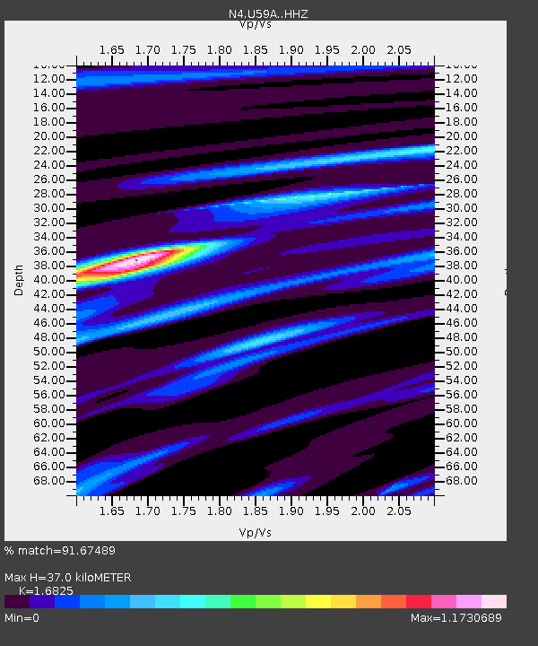
| Estimated Moho Depth: |
37.0 km |
| Estimated Crust Vp/Vs: |
1.68 |
| Assumed Crust Vp: |
6.565 km/s |
| Estimated Crust Vs: |
3.902 km/s |
| Estimated Crust Poisson's Ratio: |
0.23 |
|
| Radial Match: |
91.67489 % |
| Radial Bump: |
194 |
| Transverse Match: |
69.84876 % |
| Transverse Bump: |
400 |
| SOD ConfigId: |
7422571 |
| Insert Time: |
2019-04-22 14:40:53.833 +0000 |
| GWidth: |
2.5 |
| Max Bumps: |
400 |
| Tol: |
0.001 |
|

Signal To Noise
| Channel | StoN | STA | LTA |
| N4:U59A: :HHZ:20160518T08:03:30.260011Z | 34.710705 | 4.543477E-6 | 1.3089556E-7 |
| N4:U59A: :HHN:20160518T08:03:30.260011Z | 23.76881 | 2.8585198E-6 | 1.2026348E-7 |
| N4:U59A: :HHE:20160518T08:03:30.260011Z | 4.647726 | 5.470695E-7 | 1.17706904E-7 |
| Arrivals |
| Ps | 4.2 SECOND |
| PpPs | 14 SECOND |
| PsPs/PpSs | 18 SECOND |


