You are here: Home > Network List > US - United States National Seismic Network Stations List
> Station SDCO Great Sand Dunes National Park, Colorado, USA > Earthquake Result Viewer
SDCO Great Sand Dunes National Park, Colorado, USA - Earthquake Result Viewer
| Earthquake location: |
Near Coast Of Northern Chile |
| Earthquake latitude/longitude: |
-22.9/-70.2 |
| Earthquake time(UTC): |
2007/11/15 (319) 15:05:58 GMT |
| Earthquake Depth: |
26 km |
| Earthquake Magnitude: |
6.1 MB, 6.6 MS, 6.8 MW, 6.6 MW |
| Earthquake Catalog/Contributor: |
WHDF/NEIC |
|
| Network: |
US United States National Seismic Network |
| Station: |
SDCO Great Sand Dunes National Park, Colorado, USA |
| Lat/Lon: |
37.75 N/105.50 W |
| Elevation: |
2569 m |
|
| Distance: |
68.9 deg |
| Az: |
330.614 deg |
| Baz: |
145.202 deg |
| Ray Param: |
0.055993132 |
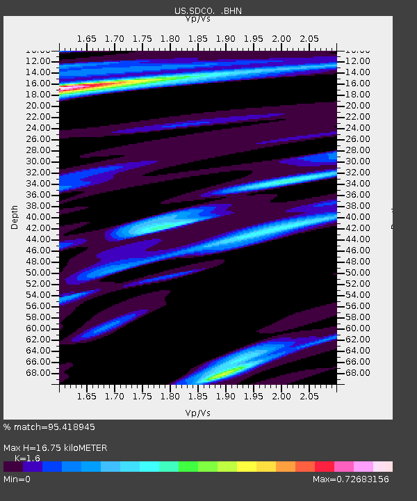
| Estimated Moho Depth: |
16.75 km |
| Estimated Crust Vp/Vs: |
1.60 |
| Assumed Crust Vp: |
6.316 km/s |
| Estimated Crust Vs: |
3.947 km/s |
| Estimated Crust Poisson's Ratio: |
0.18 |
|
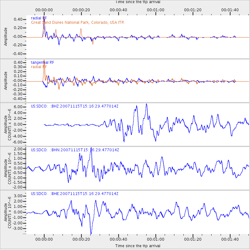
| Radial Match: |
95.418945 % |
| Radial Bump: |
289 |
| Transverse Match: |
94.000824 % |
| Transverse Bump: |
400 |
| SOD ConfigId: |
2564 |
| Insert Time: |
2010-03-05 03:11:54.980 +0000 |
| GWidth: |
2.5 |
| Max Bumps: |
400 |
| Tol: |
0.001 |
|
Signal To Noise
| Channel | StoN | STA | LTA |
| US:SDCO: :BHN:20071115T15:16:29.477014Z | 2.2897904 | 1.9770914E-7 | 8.6343775E-8 |
| US:SDCO: :BHE:20071115T15:16:29.477014Z | 2.3873343 | 3.0461936E-7 | 1.2759811E-7 |
| US:SDCO: :BHZ:20071115T15:16:29.477014Z | 3.1484694 | 5.616953E-7 | 1.7840264E-7 |
| Arrivals |
| Ps | 1.7 SECOND |
| PpPs | 6.6 SECOND |
| PsPs/PpSs | 8.3 SECOND |


