You are here: Home > Network List > NY - Yukon Northwest Seismic Network(YNSN) Stations List
> Station MMPY Sheldon Lake, Yukon, CANADA > Earthquake Result Viewer
MMPY Sheldon Lake, Yukon, CANADA - Earthquake Result Viewer
| Earthquake location: |
Near Coast Of Ecuador |
| Earthquake latitude/longitude: |
0.4/-79.8 |
| Earthquake time(UTC): |
2016/05/18 (139) 07:57:05 GMT |
| Earthquake Depth: |
32 km |
| Earthquake Magnitude: |
6.7 MWP, 6.7 MWW, 6.7 MI |
| Earthquake Catalog/Contributor: |
NEIC PDE/NEIC COMCAT |
|
| Network: |
NY Yukon Northwest Seismic Network(YNSN) |
| Station: |
MMPY Sheldon Lake, Yukon, CANADA |
| Lat/Lon: |
62.62 N/131.26 W |
| Elevation: |
0.0 m |
|
| Distance: |
72.9 deg |
| Az: |
337.753 deg |
| Baz: |
125.03 deg |
| Ray Param: |
0.05332515 |
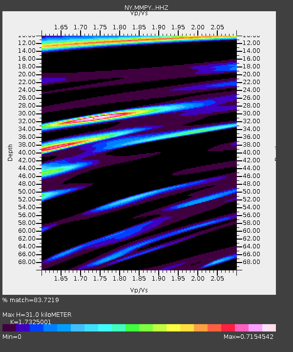
| Estimated Moho Depth: |
31.0 km |
| Estimated Crust Vp/Vs: |
1.73 |
| Assumed Crust Vp: |
6.419 km/s |
| Estimated Crust Vs: |
3.705 km/s |
| Estimated Crust Poisson's Ratio: |
0.25 |
|
| Radial Match: |
83.7219 % |
| Radial Bump: |
400 |
| Transverse Match: |
71.634384 % |
| Transverse Bump: |
400 |
| SOD ConfigId: |
7422571 |
| Insert Time: |
2019-04-22 14:42:06.588 +0000 |
| GWidth: |
2.5 |
| Max Bumps: |
400 |
| Tol: |
0.001 |
|

Signal To Noise
| Channel | StoN | STA | LTA |
| NY:MMPY: :HHZ:20160518T08:07:59.410005Z | 13.304015 | 2.2495576E-6 | 1.6908862E-7 |
| NY:MMPY: :HHN:20160518T08:07:59.410005Z | 4.9021587 | 3.47659E-7 | 7.091957E-8 |
| NY:MMPY: :HHE:20160518T08:07:59.410005Z | 1.9618893 | 5.139261E-7 | 2.6195468E-7 |
| Arrivals |
| Ps | 3.7 SECOND |
| PpPs | 13 SECOND |
| PsPs/PpSs | 16 SECOND |


