You are here: Home > Network List > PB - Plate Boundary Observatory Borehole Seismic Network Stations List
> Station B088A skyoks088bcs2007, Anza, CA, USA > Earthquake Result Viewer
B088A skyoks088bcs2007, Anza, CA, USA - Earthquake Result Viewer
| Earthquake location: |
Near Coast Of Ecuador |
| Earthquake latitude/longitude: |
0.4/-79.8 |
| Earthquake time(UTC): |
2016/05/18 (139) 07:57:05 GMT |
| Earthquake Depth: |
32 km |
| Earthquake Magnitude: |
6.7 MWP, 6.7 MWW, 6.7 MI |
| Earthquake Catalog/Contributor: |
NEIC PDE/NEIC COMCAT |
|
| Network: |
PB Plate Boundary Observatory Borehole Seismic Network |
| Station: |
B088A skyoks088bcs2007, Anza, CA, USA |
| Lat/Lon: |
33.37 N/116.62 W |
| Elevation: |
1404 m |
|
| Distance: |
47.7 deg |
| Az: |
317.229 deg |
| Baz: |
125.757 deg |
| Ray Param: |
0.069790326 |
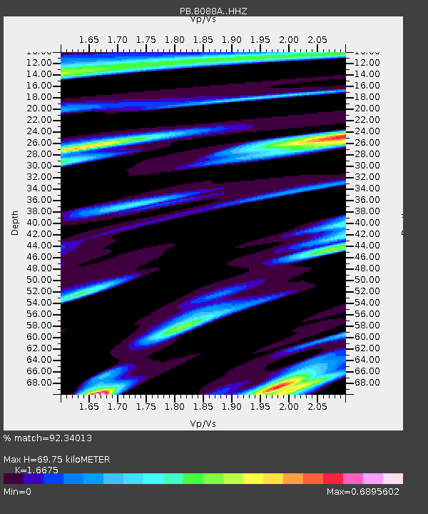
| Estimated Moho Depth: |
69.75 km |
| Estimated Crust Vp/Vs: |
1.67 |
| Assumed Crust Vp: |
6.264 km/s |
| Estimated Crust Vs: |
3.756 km/s |
| Estimated Crust Poisson's Ratio: |
0.22 |
|
| Radial Match: |
92.34013 % |
| Radial Bump: |
340 |
| Transverse Match: |
74.71607 % |
| Transverse Bump: |
400 |
| SOD ConfigId: |
7422571 |
| Insert Time: |
2019-04-22 14:42:40.252 +0000 |
| GWidth: |
2.5 |
| Max Bumps: |
400 |
| Tol: |
0.001 |
|

Signal To Noise
| Channel | StoN | STA | LTA |
| PB:B088A: :HHZ:20160518T08:05:07.009004Z | 4.5440583 | 5.746384E-7 | 1.264593E-7 |
| PB:B088A: :HHN:20160518T08:05:07.009004Z | 1.4182894 | 2.1262613E-7 | 1.4991731E-7 |
| PB:B088A: :HHE:20160518T08:05:07.009004Z | 1.1908729 | 2.5071392E-7 | 2.1052955E-7 |
| Arrivals |
| Ps | 7.9 SECOND |
| PpPs | 28 SECOND |
| PsPs/PpSs | 36 SECOND |


