You are here: Home > Network List > US - United States National Seismic Network Stations List
> Station SDCO Great Sand Dunes National Park, Colorado, USA > Earthquake Result Viewer
SDCO Great Sand Dunes National Park, Colorado, USA - Earthquake Result Viewer
| Earthquake location: |
Komandorskiye Ostrova Region |
| Earthquake latitude/longitude: |
53.6/169.7 |
| Earthquake time(UTC): |
2007/07/29 (210) 04:54:36 GMT |
| Earthquake Depth: |
26 km |
| Earthquake Magnitude: |
6.0 MB, 5.5 MS, 5.9 MW, 5.8 MW |
| Earthquake Catalog/Contributor: |
WHDF/NEIC |
|
| Network: |
US United States National Seismic Network |
| Station: |
SDCO Great Sand Dunes National Park, Colorado, USA |
| Lat/Lon: |
37.75 N/105.50 W |
| Elevation: |
2569 m |
|
| Distance: |
57.8 deg |
| Az: |
68.863 deg |
| Baz: |
315.526 deg |
| Ray Param: |
0.06320768 |
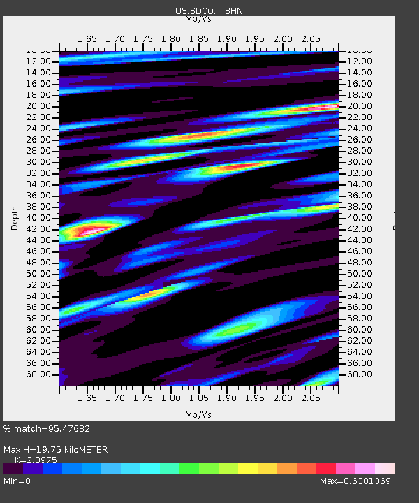
| Estimated Moho Depth: |
19.75 km |
| Estimated Crust Vp/Vs: |
2.10 |
| Assumed Crust Vp: |
6.316 km/s |
| Estimated Crust Vs: |
3.011 km/s |
| Estimated Crust Poisson's Ratio: |
0.35 |
|
| Radial Match: |
95.47682 % |
| Radial Bump: |
400 |
| Transverse Match: |
93.86214 % |
| Transverse Bump: |
321 |
| SOD ConfigId: |
2564 |
| Insert Time: |
2010-03-05 03:12:24.969 +0000 |
| GWidth: |
2.5 |
| Max Bumps: |
400 |
| Tol: |
0.001 |
|
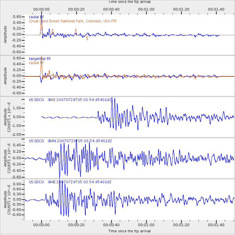
Signal To Noise
| Channel | StoN | STA | LTA |
| US:SDCO: :BHN:20070729T05:03:54.954019Z | 2.3156583 | 8.064915E-8 | 3.4827742E-8 |
| US:SDCO: :BHE:20070729T05:03:54.954019Z | 4.108358 | 1.345289E-7 | 3.2745177E-8 |
| US:SDCO: :BHZ:20070729T05:03:54.954019Z | 5.6656237 | 2.7198195E-7 | 4.800565E-8 |
| Arrivals |
| Ps | 3.6 SECOND |
| PpPs | 9.3 SECOND |
| PsPs/PpSs | 13 SECOND |


