You are here: Home > Network List > PE - Penn State Network Stations List
> Station PACW Cowans Gap State Park, Fort Loudon, PA > Earthquake Result Viewer
PACW Cowans Gap State Park, Fort Loudon, PA - Earthquake Result Viewer
| Earthquake location: |
Near Coast Of Ecuador |
| Earthquake latitude/longitude: |
0.4/-79.8 |
| Earthquake time(UTC): |
2016/05/18 (139) 07:57:05 GMT |
| Earthquake Depth: |
32 km |
| Earthquake Magnitude: |
6.7 MWP, 6.7 MWW, 6.7 MI |
| Earthquake Catalog/Contributor: |
NEIC PDE/NEIC COMCAT |
|
| Network: |
PE Penn State Network |
| Station: |
PACW Cowans Gap State Park, Fort Loudon, PA |
| Lat/Lon: |
40.00 N/77.92 W |
| Elevation: |
394 m |
|
| Distance: |
39.4 deg |
| Az: |
2.227 deg |
| Baz: |
182.899 deg |
| Ray Param: |
0.07493546 |
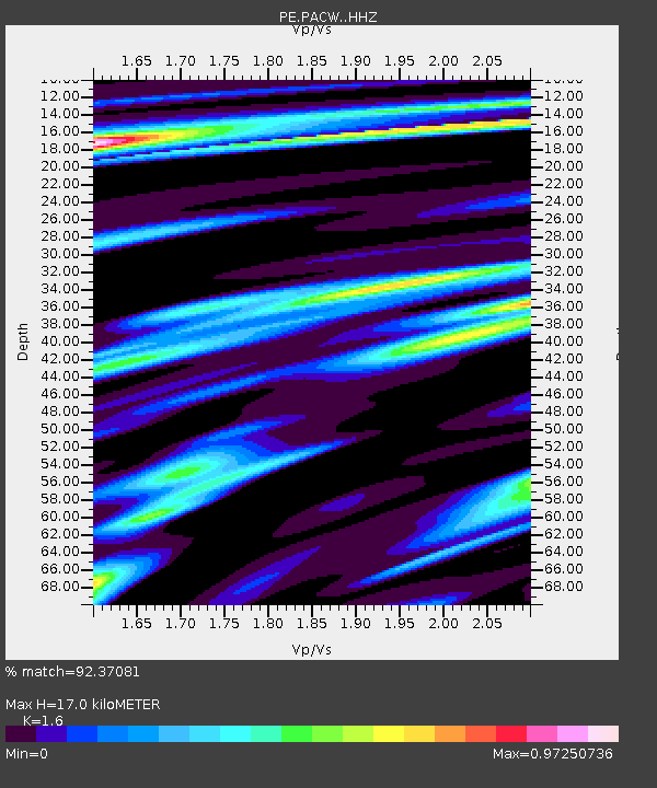
| Estimated Moho Depth: |
17.0 km |
| Estimated Crust Vp/Vs: |
1.60 |
| Assumed Crust Vp: |
6.419 km/s |
| Estimated Crust Vs: |
4.012 km/s |
| Estimated Crust Poisson's Ratio: |
0.18 |
|
| Radial Match: |
92.37081 % |
| Radial Bump: |
301 |
| Transverse Match: |
72.16057 % |
| Transverse Bump: |
400 |
| SOD ConfigId: |
7422571 |
| Insert Time: |
2019-04-22 14:42:41.788 +0000 |
| GWidth: |
2.5 |
| Max Bumps: |
400 |
| Tol: |
0.001 |
|

Signal To Noise
| Channel | StoN | STA | LTA |
| PE:PACW: :HHZ:20160518T08:04:00.880006Z | 25.315535 | 4.248325E-6 | 1.6781493E-7 |
| PE:PACW: :HHN:20160518T08:04:00.880006Z | 17.217373 | 2.5234322E-6 | 1.4656314E-7 |
| PE:PACW: :HHE:20160518T08:04:00.880006Z | 5.44454 | 5.9389635E-7 | 1.09081085E-7 |
| Arrivals |
| Ps | 1.7 SECOND |
| PpPs | 6.4 SECOND |
| PsPs/PpSs | 8.1 SECOND |


