You are here: Home > Network List > US - United States National Seismic Network Stations List
> Station SDCO Great Sand Dunes National Park, Colorado, USA > Earthquake Result Viewer
SDCO Great Sand Dunes National Park, Colorado, USA - Earthquake Result Viewer
| Earthquake location: |
Jujuy Province, Argentina |
| Earthquake latitude/longitude: |
-22.2/-65.8 |
| Earthquake time(UTC): |
2007/07/21 (202) 15:34:52 GMT |
| Earthquake Depth: |
290 km |
| Earthquake Magnitude: |
5.8 MB, 6.4 MW, 6.3 MW |
| Earthquake Catalog/Contributor: |
WHDF/NEIC |
|
| Network: |
US United States National Seismic Network |
| Station: |
SDCO Great Sand Dunes National Park, Colorado, USA |
| Lat/Lon: |
37.75 N/105.50 W |
| Elevation: |
2569 m |
|
| Distance: |
70.3 deg |
| Az: |
327.45 deg |
| Baz: |
141.007 deg |
| Ray Param: |
0.054211404 |
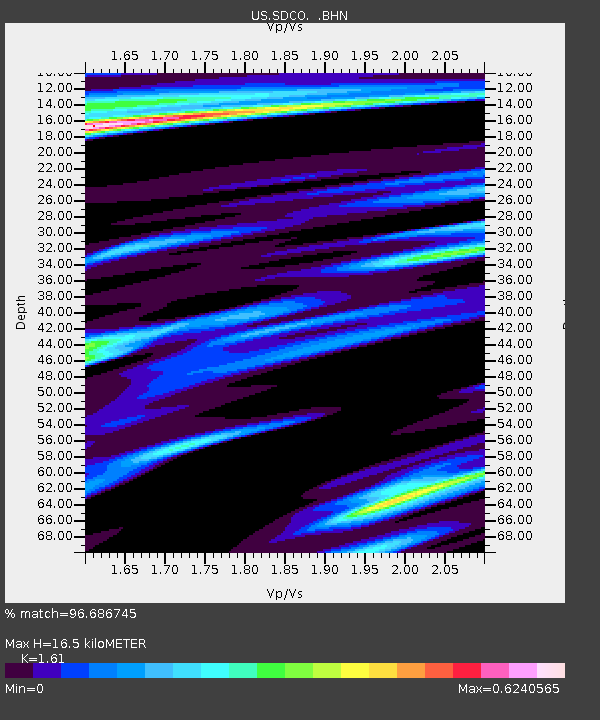
| Estimated Moho Depth: |
16.5 km |
| Estimated Crust Vp/Vs: |
1.61 |
| Assumed Crust Vp: |
6.316 km/s |
| Estimated Crust Vs: |
3.923 km/s |
| Estimated Crust Poisson's Ratio: |
0.19 |
|
| Radial Match: |
96.686745 % |
| Radial Bump: |
346 |
| Transverse Match: |
93.19504 % |
| Transverse Bump: |
357 |
| SOD ConfigId: |
2564 |
| Insert Time: |
2010-03-05 03:12:25.948 +0000 |
| GWidth: |
2.5 |
| Max Bumps: |
400 |
| Tol: |
0.001 |
|

Signal To Noise
| Channel | StoN | STA | LTA |
| US:SDCO: :BHN:20070721T15:45:04.152002Z | 2.4269145 | 1.0505549E-7 | 4.3287677E-8 |
| US:SDCO: :BHE:20070721T15:45:04.152002Z | 2.82631 | 1.07817456E-7 | 3.8147782E-8 |
| US:SDCO: :BHZ:20070721T15:45:04.152002Z | 10.85783 | 4.189637E-7 | 3.8586318E-8 |
| Arrivals |
| Ps | 1.7 SECOND |
| PpPs | 6.6 SECOND |
| PsPs/PpSs | 8.2 SECOND |


