You are here: Home > Network List > PE - Penn State Network Stations List
> Station PSUB Penn State - Brandywine Campus > Earthquake Result Viewer
PSUB Penn State - Brandywine Campus - Earthquake Result Viewer
| Earthquake location: |
Near Coast Of Ecuador |
| Earthquake latitude/longitude: |
0.4/-79.8 |
| Earthquake time(UTC): |
2016/05/18 (139) 07:57:05 GMT |
| Earthquake Depth: |
32 km |
| Earthquake Magnitude: |
6.7 MWP, 6.7 MWW, 6.7 MI |
| Earthquake Catalog/Contributor: |
NEIC PDE/NEIC COMCAT |
|
| Network: |
PE Penn State Network |
| Station: |
PSUB Penn State - Brandywine Campus |
| Lat/Lon: |
39.93 N/75.45 W |
| Elevation: |
110 m |
|
| Distance: |
39.5 deg |
| Az: |
5.216 deg |
| Baz: |
186.79 deg |
| Ray Param: |
0.074881665 |
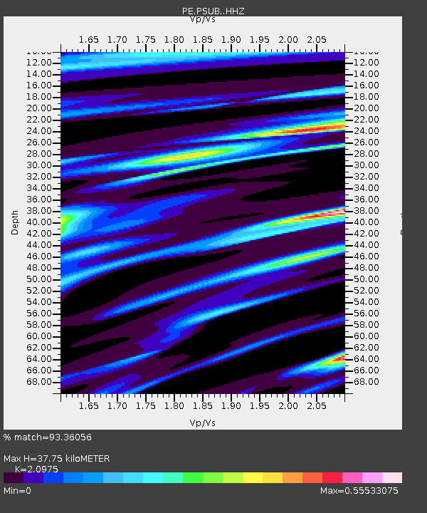
| Estimated Moho Depth: |
37.75 km |
| Estimated Crust Vp/Vs: |
2.10 |
| Assumed Crust Vp: |
6.287 km/s |
| Estimated Crust Vs: |
2.998 km/s |
| Estimated Crust Poisson's Ratio: |
0.35 |
|
| Radial Match: |
93.36056 % |
| Radial Bump: |
336 |
| Transverse Match: |
77.789246 % |
| Transverse Bump: |
400 |
| SOD ConfigId: |
7422571 |
| Insert Time: |
2019-04-22 14:42:51.855 +0000 |
| GWidth: |
2.5 |
| Max Bumps: |
400 |
| Tol: |
0.001 |
|

Signal To Noise
| Channel | StoN | STA | LTA |
| PE:PSUB: :HHZ:20160518T08:04:01.690004Z | 37.883907 | 7.561202E-6 | 1.9958875E-7 |
| PE:PSUB: :HHN:20160518T08:04:01.690004Z | 28.884598 | 4.3382493E-6 | 1.5019248E-7 |
| PE:PSUB: :HHE:20160518T08:04:01.690004Z | 3.5864303 | 7.699481E-7 | 2.1468368E-7 |
| Arrivals |
| Ps | 7.0 SECOND |
| PpPs | 18 SECOND |
| PsPs/PpSs | 25 SECOND |


