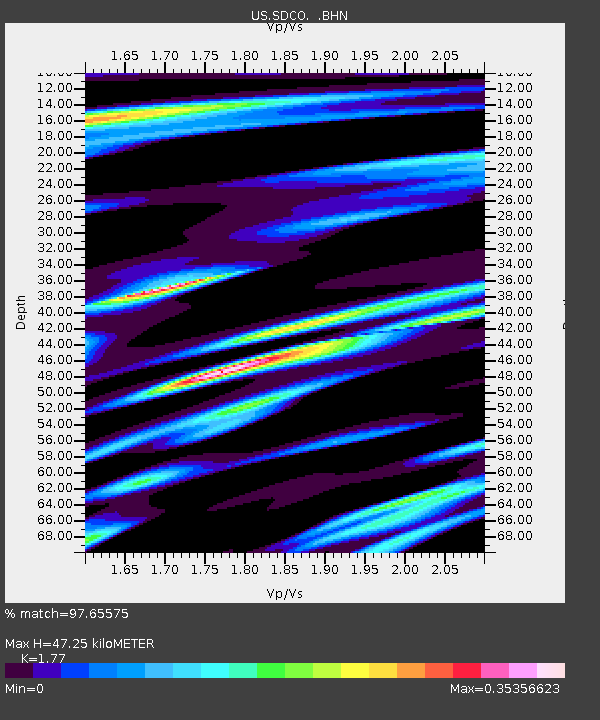
SDCO Great Sand Dunes National Park, Colorado, USA - Earthquake Result Viewer

Earthquake location: Near West Coast Of Honshu, Japan
Earthquake latitude/longitude: 37.5/138.4
Earthquake time(UTC): 2007/07/16 (197) 01:13:22 GMT
Earthquake Depth: 12 km
Earthquake Magnitude: 6.5 MB, 6.4 MS, 6.6 MW, 6.5 MW
Earthquake Catalog/Contributor: WHDF/NEIC
Network: US United States National Seismic Network
Station: SDCO Great Sand Dunes National Park, Colorado, USA
Lat/Lon: 37.75 N/105.50 W
Elevation: 2569 m
Distance: 84.7 deg
Az: 45.666 deg
Baz: 314.169 deg
Ray Param: 0.045319192
Estimated Moho Depth: 47.25 km
Estimated Crust Vp/Vs: 1.77
Assumed Crust Vp: 6.316 km/s
Estimated Crust Vs: 3.568 km/s
Estimated Crust Poisson's Ratio: 0.27
Radial Match: 97.65575 %
Radial Bump: 335
Transverse Match: 95.59099 %
Transverse Bump: 400
SOD ConfigId: 2564
Insert Time: 2010-03-05 03:12:34.766 +0000
GWidth: 2.5
Max Bumps: 400
Tol: 0.001

Signal To Noise

ChannelStoNSTALTA
US:SDCO: :BHN:20070716T01:25:24.330022Z8.19364552.9418206E-73.5903685E-8
US:SDCO: :BHE:20070716T01:25:24.330022Z24.063995.650903E-72.3482817E-8
US:SDCO: :BHZ:20070716T01:25:24.330022Z29.0134941.8773441E-66.4705894E-8
Arrivals
Ps5.9 SECOND
PpPs20 SECOND
PsPs/PpSs26 SECOND