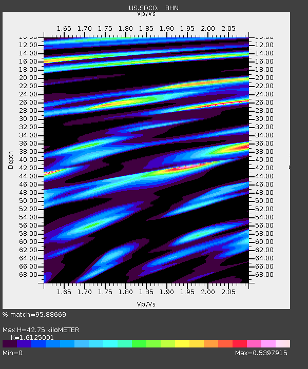
SDCO Great Sand Dunes National Park, Colorado, USA - Earthquake Result Viewer

Earthquake location: Andreanof Islands, Aleutian Is.
Earthquake latitude/longitude: 51.8/-176.3
Earthquake time(UTC): 2007/07/13 (194) 21:54:43 GMT
Earthquake Depth: 35 km
Earthquake Magnitude: 5.7 MB, 5.6 MS, 6.0 MW, 5.9 MW
Earthquake Catalog/Contributor: WHDF/NEIC
Network: US United States National Seismic Network
Station: SDCO Great Sand Dunes National Park, Colorado, USA
Lat/Lon: 37.75 N/105.50 W
Elevation: 2569 m
Distance: 50.2 deg
Az: 76.947 deg
Baz: 310.318 deg
Ray Param: 0.06813986
Estimated Moho Depth: 42.75 km
Estimated Crust Vp/Vs: 1.61
Assumed Crust Vp: 6.316 km/s
Estimated Crust Vs: 3.917 km/s
Estimated Crust Poisson's Ratio: 0.19
Radial Match: 95.88669 %
Radial Bump: 311
Transverse Match: 92.70734 %
Transverse Bump: 400
SOD ConfigId: 2564
Insert Time: 2010-03-05 03:12:40.429 +0000
GWidth: 2.5
Max Bumps: 400
Tol: 0.001

Signal To Noise

ChannelStoNSTALTA
US:SDCO: :BHN:20070713T22:03:04.978011Z7.54859921.869737E-72.4769323E-8
US:SDCO: :BHE:20070713T22:03:04.978011Z15.3937263.7628027E-72.4443741E-8
US:SDCO: :BHZ:20070713T22:03:04.978011Z15.8114047.9834575E-75.0491767E-8
Arrivals
Ps4.4 SECOND
PpPs17 SECOND
PsPs/PpSs21 SECOND