You are here: Home > Network List > TA - USArray Transportable Network (new EarthScope stations) Stations List
> Station J29M Klondike Camp, Yukon, CA > Earthquake Result Viewer
J29M Klondike Camp, Yukon, CA - Earthquake Result Viewer
| Earthquake location: |
Near Coast Of Ecuador |
| Earthquake latitude/longitude: |
0.4/-79.8 |
| Earthquake time(UTC): |
2016/05/18 (139) 07:57:05 GMT |
| Earthquake Depth: |
32 km |
| Earthquake Magnitude: |
6.7 MWP, 6.7 MWW, 6.7 MI |
| Earthquake Catalog/Contributor: |
NEIC PDE/NEIC COMCAT |
|
| Network: |
TA USArray Transportable Network (new EarthScope stations) |
| Station: |
J29M Klondike Camp, Yukon, CA |
| Lat/Lon: |
64.45 N/138.22 W |
| Elevation: |
982 m |
|
| Distance: |
76.5 deg |
| Az: |
337.664 deg |
| Baz: |
118.788 deg |
| Ray Param: |
0.05091197 |
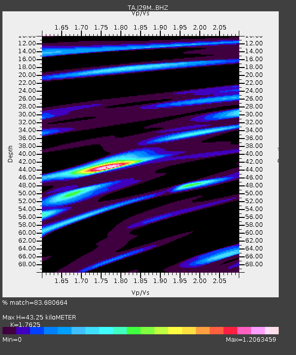
| Estimated Moho Depth: |
43.25 km |
| Estimated Crust Vp/Vs: |
1.76 |
| Assumed Crust Vp: |
6.566 km/s |
| Estimated Crust Vs: |
3.725 km/s |
| Estimated Crust Poisson's Ratio: |
0.26 |
|
| Radial Match: |
83.680664 % |
| Radial Bump: |
400 |
| Transverse Match: |
78.645905 % |
| Transverse Bump: |
400 |
| SOD ConfigId: |
7422571 |
| Insert Time: |
2019-04-22 14:44:05.744 +0000 |
| GWidth: |
2.5 |
| Max Bumps: |
400 |
| Tol: |
0.001 |
|

Signal To Noise
| Channel | StoN | STA | LTA |
| TA:J29M: :BHZ:20160518T08:08:20.324983Z | 10.03663 | 1.6045677E-6 | 1.5987118E-7 |
| TA:J29M: :BHN:20160518T08:08:20.324983Z | 2.7456052 | 6.0562866E-7 | 2.205811E-7 |
| TA:J29M: :BHE:20160518T08:08:20.324983Z | 4.186796 | 9.119774E-7 | 2.1782225E-7 |
| Arrivals |
| Ps | 5.2 SECOND |
| PpPs | 18 SECOND |
| PsPs/PpSs | 23 SECOND |


