You are here: Home > Network List > TA - USArray Transportable Network (new EarthScope stations) Stations List
> Station K27K Chicken, AK, USA > Earthquake Result Viewer
K27K Chicken, AK, USA - Earthquake Result Viewer
| Earthquake location: |
Near Coast Of Ecuador |
| Earthquake latitude/longitude: |
0.4/-79.8 |
| Earthquake time(UTC): |
2016/05/18 (139) 07:57:05 GMT |
| Earthquake Depth: |
32 km |
| Earthquake Magnitude: |
6.7 MWP, 6.7 MWW, 6.7 MI |
| Earthquake Catalog/Contributor: |
NEIC PDE/NEIC COMCAT |
|
| Network: |
TA USArray Transportable Network (new EarthScope stations) |
| Station: |
K27K Chicken, AK, USA |
| Lat/Lon: |
64.03 N/142.08 W |
| Elevation: |
389 m |
|
| Distance: |
77.8 deg |
| Az: |
336.492 deg |
| Baz: |
115.055 deg |
| Ray Param: |
0.050028212 |
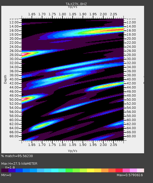
| Estimated Moho Depth: |
27.5 km |
| Estimated Crust Vp/Vs: |
1.60 |
| Assumed Crust Vp: |
6.566 km/s |
| Estimated Crust Vs: |
4.104 km/s |
| Estimated Crust Poisson's Ratio: |
0.18 |
|
| Radial Match: |
95.56238 % |
| Radial Bump: |
397 |
| Transverse Match: |
88.31806 % |
| Transverse Bump: |
400 |
| SOD ConfigId: |
7422571 |
| Insert Time: |
2019-04-22 14:44:10.222 +0000 |
| GWidth: |
2.5 |
| Max Bumps: |
400 |
| Tol: |
0.001 |
|

Signal To Noise
| Channel | StoN | STA | LTA |
| TA:K27K: :BHZ:20160518T08:08:27.649995Z | 27.041048 | 2.7872104E-6 | 1.0307331E-7 |
| TA:K27K: :BHN:20160518T08:08:27.649995Z | 5.036538 | 3.638331E-7 | 7.223872E-8 |
| TA:K27K: :BHE:20160518T08:08:27.649995Z | 10.901371 | 9.663926E-7 | 8.8648726E-8 |
| Arrivals |
| Ps | 2.6 SECOND |
| PpPs | 11 SECOND |
| PsPs/PpSs | 13 SECOND |


