You are here: Home > Network List > TA - USArray Transportable Network (new EarthScope stations) Stations List
> Station O30N Mendenhall, YT, Canada > Earthquake Result Viewer
O30N Mendenhall, YT, Canada - Earthquake Result Viewer
| Earthquake location: |
Near Coast Of Ecuador |
| Earthquake latitude/longitude: |
0.4/-79.8 |
| Earthquake time(UTC): |
2016/05/18 (139) 07:57:05 GMT |
| Earthquake Depth: |
32 km |
| Earthquake Magnitude: |
6.7 MWP, 6.7 MWW, 6.7 MI |
| Earthquake Catalog/Contributor: |
NEIC PDE/NEIC COMCAT |
|
| Network: |
TA USArray Transportable Network (new EarthScope stations) |
| Station: |
O30N Mendenhall, YT, Canada |
| Lat/Lon: |
60.77 N/136.09 W |
| Elevation: |
821 m |
|
| Distance: |
73.8 deg |
| Az: |
334.831 deg |
| Baz: |
119.947 deg |
| Ray Param: |
0.05269972 |
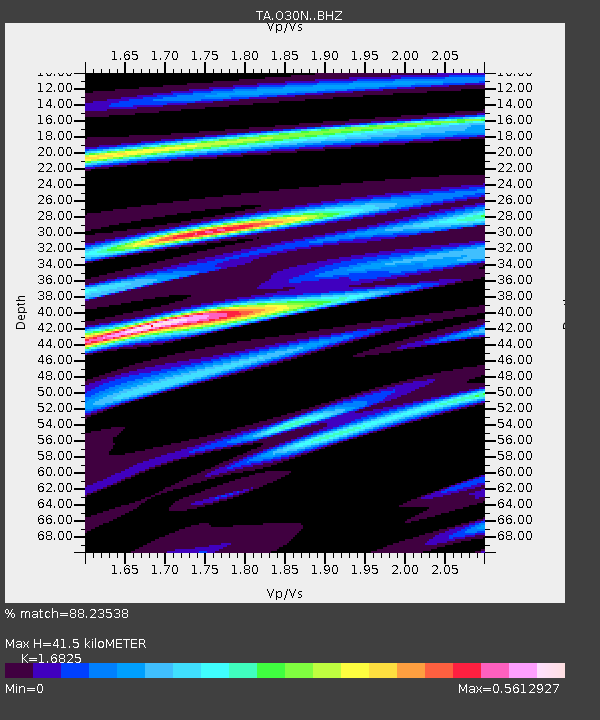
| Estimated Moho Depth: |
41.5 km |
| Estimated Crust Vp/Vs: |
1.68 |
| Assumed Crust Vp: |
6.566 km/s |
| Estimated Crust Vs: |
3.903 km/s |
| Estimated Crust Poisson's Ratio: |
0.23 |
|
| Radial Match: |
88.23538 % |
| Radial Bump: |
344 |
| Transverse Match: |
73.25303 % |
| Transverse Bump: |
400 |
| SOD ConfigId: |
7422571 |
| Insert Time: |
2019-04-22 14:44:37.234 +0000 |
| GWidth: |
2.5 |
| Max Bumps: |
400 |
| Tol: |
0.001 |
|

Signal To Noise
| Channel | StoN | STA | LTA |
| TA:O30N: :BHZ:20160518T08:08:04.975007Z | 10.400644 | 1.807792E-6 | 1.738154E-7 |
| TA:O30N: :BHN:20160518T08:08:04.975007Z | 1.3679771 | 2.5769145E-7 | 1.8837409E-7 |
| TA:O30N: :BHE:20160518T08:08:04.975007Z | 2.4252424 | 6.266006E-7 | 2.5836616E-7 |
| Arrivals |
| Ps | 4.5 SECOND |
| PpPs | 16 SECOND |
| PsPs/PpSs | 21 SECOND |


