SDCO Great Sand Dunes National Park, Colorado, USA - Earthquake Result Viewer
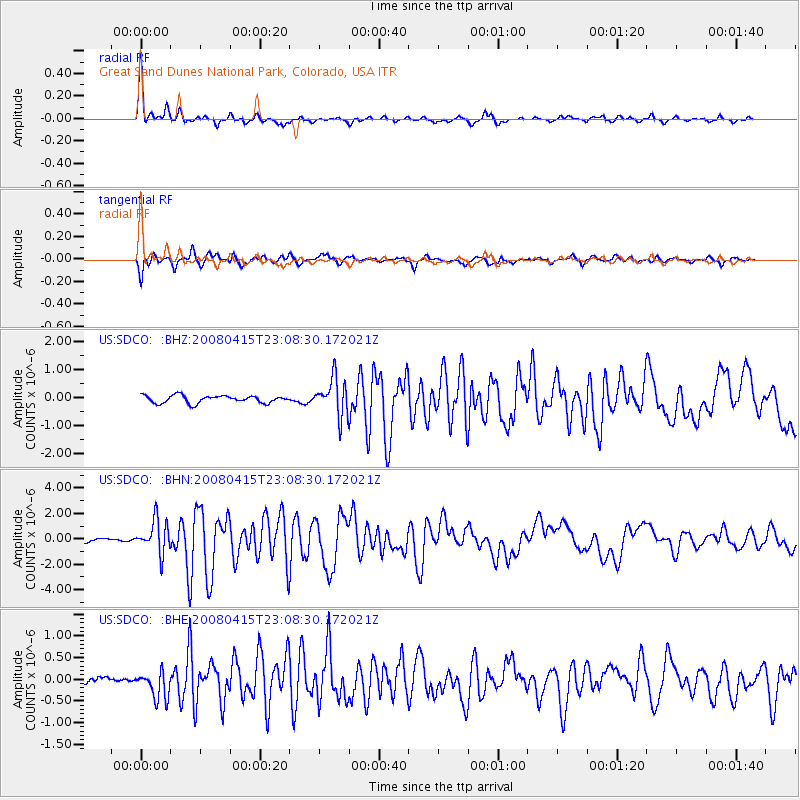
Earthquake location: Andreanof Islands, Aleutian Is.
Earthquake latitude/longitude: 51.9/-179.4
Earthquake time(UTC): 2008/04/15 (106) 22:59:51 GMT
Earthquake Depth: 10 km
Earthquake Magnitude: 6.1 MB, 6.4 MS, 6.4 MW, 6.4 MW
Earthquake Catalog/Contributor: WHDF/NEIC
Network: US United States National Seismic Network
Station: SDCO Great Sand Dunes National Park, Colorado, USA
Lat/Lon: 37.75 N/105.50 W
Elevation: 2569 m
Distance: 52.1 deg
Az: 74.919 deg
Baz: 310.934 deg
Ray Param: 0.06700481
Estimated Moho Depth: 45.25 km
Estimated Crust Vp/Vs: 1.88
Assumed Crust Vp: 6.316 km/s
Estimated Crust Vs: 3.355 km/s
Estimated Crust Poisson's Ratio: 0.30
Radial Match: 94.42876 %
Radial Bump: 314
Transverse Match: 90.80163 %
Transverse Bump: 400
SOD ConfigId: 2504
Insert Time: 2010-03-05 03:13:02.782 +0000
GWidth: 2.5
Max Bumps: 400
Tol: 0.001

Signal To Noise

ChannelStoNSTALTA
US:SDCO: :BHN:20080415T23:08:30.172021Z12.0367511.2837304E-61.0665091E-7
US:SDCO: :BHE:20080415T23:08:30.172021Z4.34124763.105174E-77.152723E-8
US:SDCO: :BHZ:20080415T23:08:30.172021Z5.0903156.6979106E-71.3158146E-7
Arrivals
Ps6.7 SECOND
PpPs20 SECOND
PsPs/PpSs26 SECOND