You are here: Home > Network List > TA - USArray Transportable Network (new EarthScope stations) Stations List
> Station TCOL CIGO, UAF Yankovich Road, Fairbanks, AK, USA > Earthquake Result Viewer
TCOL CIGO, UAF Yankovich Road, Fairbanks, AK, USA - Earthquake Result Viewer
| Earthquake location: |
Near Coast Of Ecuador |
| Earthquake latitude/longitude: |
0.4/-79.8 |
| Earthquake time(UTC): |
2016/05/18 (139) 07:57:05 GMT |
| Earthquake Depth: |
32 km |
| Earthquake Magnitude: |
6.7 MWP, 6.7 MWW, 6.7 MI |
| Earthquake Catalog/Contributor: |
NEIC PDE/NEIC COMCAT |
|
| Network: |
TA USArray Transportable Network (new EarthScope stations) |
| Station: |
TCOL CIGO, UAF Yankovich Road, Fairbanks, AK, USA |
| Lat/Lon: |
64.87 N/147.86 W |
| Elevation: |
178 m |
|
| Distance: |
80.4 deg |
| Az: |
336.315 deg |
| Baz: |
109.807 deg |
| Ray Param: |
0.04822767 |
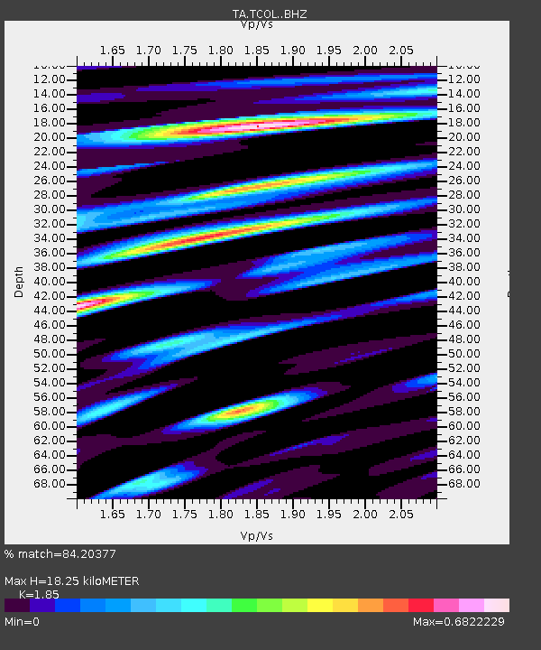
| Estimated Moho Depth: |
18.25 km |
| Estimated Crust Vp/Vs: |
1.85 |
| Assumed Crust Vp: |
6.566 km/s |
| Estimated Crust Vs: |
3.549 km/s |
| Estimated Crust Poisson's Ratio: |
0.29 |
|
| Radial Match: |
84.20377 % |
| Radial Bump: |
400 |
| Transverse Match: |
56.77245 % |
| Transverse Bump: |
400 |
| SOD ConfigId: |
7422571 |
| Insert Time: |
2019-04-22 14:44:52.746 +0000 |
| GWidth: |
2.5 |
| Max Bumps: |
400 |
| Tol: |
0.001 |
|

Signal To Noise
| Channel | StoN | STA | LTA |
| TA:TCOL: :BHZ:20160518T08:08:42.05002Z | 17.591763 | 1.973483E-6 | 1.1218222E-7 |
| TA:TCOL: :BHN:20160518T08:08:42.05002Z | 1.4958856 | 4.4619728E-7 | 2.98283E-7 |
| TA:TCOL: :BHE:20160518T08:08:42.05002Z | 3.3772576 | 6.52949E-7 | 1.9333704E-7 |
| Arrivals |
| Ps | 2.4 SECOND |
| PpPs | 7.7 SECOND |
| PsPs/PpSs | 10 SECOND |


